Howard County, Texas
| Howard County, Texas | |
|---|---|

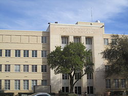
Howard County Court House in downtown Big Spring
|
|
 Location in the U.S. state of Texas |
|
 Texas's location in the U.S. |
|
| Founded | 1882 |
| Named for | Volney E. Howard |
| Seat | Big Spring |
| Largest city | Big Spring |
| Area | |
| • Total | 904 sq mi (2,341 km2) |
| • Land | 901 sq mi (2,334 km2) |
| • Water | 3 sq mi (8 km2), 0.4% |
| Population | |
| • (2010) | 35,012 |
| • Density | 39/sq mi (15/km²) |
| Congressional district | 19th |
| Time zone | Central: UTC-6/-5 |
| Website | www |
Howard County is a county located in the U.S. state of Texas. As of the 2010 census, its population was 35,012. Its county seat is Big Spring. The county was created in 1876 and organized in 1882. It is named for Volney E. Howard, a U.S. Congressman from Texas.
Howard County is included in the Big Spring, TX Micropolitan Statistical Area.
According to the U.S. Census Bureau, the county has a total area of 904 square miles (2,340 km2), of which 901 square miles (2,330 km2) is land and 3.4 square miles (8.8 km2) (0.4%) is water.
Howard County is located at the boundary between the Llano Estacado to the north and the Edwards Plateau to the south. Beals Creek, a tributary of the Colorado River flows through the center of Big Spring and divides these two major physiographic regions.
As of the census of 2000, there were 33,627 people, 11,389 households, and 7,949 families residing in the county. The population density was 37 people per square mile (14/km²). There were 13,589 housing units at an average density of 15 per square mile (6/km²). The racial makeup of the county was 80.14% White, 4.13% Black or African American, 0.59% Native American, 0.59% Asian, 0.01% Pacific Islander, 12.43% from other races, and 2.10% from two or more races. 37.46% of the population were Hispanic or Latino of any race.
...
Wikipedia
