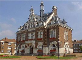
Houplines
| Houplines | ||
|---|---|---|
 |
||
|
||
| Coordinates: 50°41′29″N 2°54′37″E / 50.6914°N 2.9103°ECoordinates: 50°41′29″N 2°54′37″E / 50.6914°N 2.9103°E | ||
| Country | France | |
| Region | Hauts-de-France | |
| Department | Nord | |
| Arrondissement | Lille | |
| Canton | Armentières | |
| Intercommunality | Lille Métropole | |
| Government | ||
| • Mayor (2008–2014) | Jacques Deruyter | |
| Area1 | 11.32 km2 (4.37 sq mi) | |
| Population (1999)2 | 7,907 | |
| • Density | 700/km2 (1,800/sq mi) | |
| Time zone | CET (UTC+1) | |
| • Summer (DST) | CEST (UTC+2) | |
| INSEE/Postal code | 59317 /59116 | |
| Elevation | 12–20 m (39–66 ft) (avg. 14 m or 46 ft) |
|
|
1 French Land Register data, which excludes lakes, ponds, glaciers > 1 km² (0.386 sq mi or 247 acres) and river estuaries. 2Population without double counting: residents of multiple communes (e.g., students and military personnel) only counted once. |
||
1 French Land Register data, which excludes lakes, ponds, glaciers > 1 km² (0.386 sq mi or 247 acres) and river estuaries.
Houplines is a commune in the Nord department in northern France.
It is part of the Urban Community of Lille Métropole.
Adjoining the communal (village) cemetery is the Houplines Communal Cemetery Extension, a Commonwealth War Graves Commission maintained cemetery containing the graves of 466 identified casualties, 465 of them Commonwealth servicemen who lost their lives in the area around the village during the First World War.
Houplines maintains a partnership arrangement with the German community of Kirchhundem.
Sable, a chief argent. (Ennetières-en-Weppes, Houplines and Sailly-lez-Lannoy use the same arms.)
...
Wikipedia


