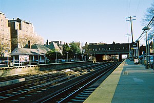
Hopedale (LIRR station)
|
Kew Gardens
|
|||||||||||||||||||||
|---|---|---|---|---|---|---|---|---|---|---|---|---|---|---|---|---|---|---|---|---|---|

Kew Gardens Station and Lefferts Boulevard Bridge
|
|||||||||||||||||||||
| Location | Austin Street & Lefferts Boulevard Kew Gardens, New York |
||||||||||||||||||||
| Coordinates | 40°42′35″N 73°49′50″W / 40.7096°N 73.83066°WCoordinates: 40°42′35″N 73°49′50″W / 40.7096°N 73.83066°W | ||||||||||||||||||||
| Owned by | Long Island Rail Road | ||||||||||||||||||||
| Line(s) | |||||||||||||||||||||
| Platforms | 2 side platforms | ||||||||||||||||||||
| Tracks | 4 | ||||||||||||||||||||
| Connections |
|
||||||||||||||||||||
| Construction | |||||||||||||||||||||
| Parking | Yes | ||||||||||||||||||||
| Other information | |||||||||||||||||||||
| Fare zone | 1 | ||||||||||||||||||||
| History | |||||||||||||||||||||
| Opened | 1879, 1883 | ||||||||||||||||||||
| Closed | 1882, 1909 | ||||||||||||||||||||
| Rebuilt | September 8, 1910 | ||||||||||||||||||||
| Electrified | June 23, 1910 750 V (DC) third rail |
||||||||||||||||||||
| Previous names | Maple Grove (1879-1910) Kew (1910-1912) |
||||||||||||||||||||
| Traffic | |||||||||||||||||||||
| Passengers (2006) | 1,631 | ||||||||||||||||||||
| Services | |||||||||||||||||||||
|
|||||||||||||||||||||
Kew Gardens is a station on the Main Line of the Long Island Rail Road in Kew Gardens, Queens. The station is located at Austin Street and Lefferts Boulevard. One of Kew Garden station's unique features is the 119th Street (Lefferts Boulevard) Bridge which has one story commercial buildings on both sides for local businesses.
Kew Gardens station originally opened in May 1879, however a Brooklyn Daily Eagle article points out that the station was not finished as of May, and others claim it was opened on December 6, 1879 as Maple Grove, a flag stop solely to give access to Maple Grove Cemetery. Using today's landmarks (which did not exist then), the Station was located in back of the Mowbray and Kew Gardens Plaza Apartments. A letter to THE LONG ISLAND FORUM, Vol 4 (Dec. 1941) says, "In 1897, I was a locomotive fireman on the L.I.R.R. and at that time the main line of the road between Jamaica and Long Island City was a single track road ... located about 150 or 200 ft. to the east of the present tracks which pass through ... Kew Gardens. A flag station known as Maple Grove was the only station between Jamaica and [Elmhurst]. This track was mostly used by freight trains except in commuting hours when some passenger trains ran over it." [John Tooker, Babylon, LI.] The station was closed in 1882, reopened in 1883, and removed in 1909 as part of the Maple Grove track realignment project.
The Maple Grove relocation was a project to reduce the curvature of the Main Line track in Kew Gardens; the Long Island Rail Road on the eve of the 1910 opening of the Pennsylvania Railroad's East River Tunnels, wanted a straight, low grade, high speed, four-track road between New York and Jamaica, and a realignment of the roadbed at Maple Grove would both straighten the road and reduce the distance by about a half mile. The new cut-off began at the present 84th Drive on the east and continued to about the present Ascan Avenue in Forest Hills. The old line ran straight from Winfield to within a few feet of Queens Boulevard at Lefferts Avenue (now Boulevard) and then curved sharply southeast and around the southern edge of Maple Grove Cemetery, producing a sharp and undesirable radius of curvature. The cut-off cut 328 feet off of the Main Line.
...
Wikipedia
