Hoonah–Angoon Census Area
| Hoonah-Angoon Census Area, Alaska | |
|---|---|

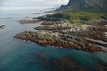
Inland Passage to Dicks Arm, view from Cape Spencer Light
|
|
 Location in the U.S. state of Alaska |
|
 Alaska's location in the U.S. |
|
| Established | 2007 |
| Largest city | Hoonah |
| Area | |
| • Total | 10,914 sq mi (28,267 km2) |
| • Land | 7,525 sq mi (19,490 km2) |
| • Water | 3,389 sq mi (8,777 km2), 31.1% |
| Population (est.) | |
| • (2016) | 2,078 |
| • Density | 0.29/sq mi (0.11/km2) |
| Congressional district | At-large |
| Time zone | Alaska: UTC−9/−8 |
Hoonah-Angoon Census Area is a census area located in the U.S. state of Alaska. As of the 2010 census, the population was 2,150. It is part of the unorganized borough and therefore has no borough seat. Its largest community is the city of Hoonah.
The census area was significantly larger in the 1990 census, at which time it was the Skagway-Yakutat-Angoon Census Area. After Yakutat was incorporated as a unified city-borough on September 22, 1992, it was renamed Skagway-Hoonah-Angoon Census Area; When Skagway followed suit on June 20, 2007, the census area assumed its current name.
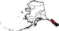
According to the U.S. Census Bureau, the census area has a total area of 10,914 square miles (28,270 km2), of which 7,525 square miles (19,490 km2) is land and 3,389 square miles (8,780 km2) (31.1%) is water. A map showing its current boundaries is shown here:
As of the census of 2000, there were 3,436 people, 1,369 households, and 866 families residing in the census area. The population density was 0.30 people per square mile (0.12/km²). There are 2,108 housing units. The racial makeup of the census area was 58.15% White, 0.15% Black or African American, 35.01% Native American, 0.38% Asian, 0.15% Pacific Islander, 0.96% from other races, and 5.21% from two or more races. 2.82% of the population were Hispanic or Latino of any race. 3.95% reported speaking Tlingit at home, while 1.83% speak Spanish [1].
...
Wikipedia
