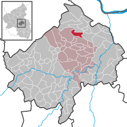
Hergenfeld
| Hergenfeld | ||
|---|---|---|
|
||
| Coordinates: 49°54′14″N 7°45′45″E / 49.90389°N 7.76250°ECoordinates: 49°54′14″N 7°45′45″E / 49.90389°N 7.76250°E | ||
| Country | Germany | |
| State | Rhineland-Palatinate | |
| District | Bad Kreuznach | |
| Municipal assoc. | Rüdesheim | |
| Government | ||
| • Mayor | Martin Theis | |
| Area | ||
| • Total | 5.90 km2 (2.28 sq mi) | |
| Elevation | 317 m (1,040 ft) | |
| Population (2015-12-31) | ||
| • Total | 509 | |
| • Density | 86/km2 (220/sq mi) | |
| Time zone | CET/CEST (UTC+1/+2) | |
| Postal codes | 55452 | |
| Dialling codes | 06706 | |
| Vehicle registration | KH | |
| Website | www.hergenfeld.de | |
Hergenfeld is an Ortsgemeinde – a municipality belonging to a Verbandsgemeinde, a kind of collective municipality – in the Bad Kreuznach district in Rhineland-Palatinate, Germany. It belongs to the Verbandsgemeinde of Rüdesheim, whose seat is in the municipality of Rüdesheim an der Nahe. Hergenfeld is a winegrowing village.
Hergenfeld lies at the foot of the Soonwald between the Naheland – the land lining each side of the Nahe – and the Hunsrück. The village is surrounded not only by cropfields and meadows, but also by woods and vineyards. Hergenfeld lies roughly 11 km northwest of the district seat of Bad Kreuznach.
Clockwise from the north, Hergenfeld’s neighbours are the municipalities of Schöneberg, Windesheim, Wallhausen and Spabrücken, all of which likewise lie within the Bad Kreuznach district.
Also belonging to Hergenfeld is the outlying homestead of Georgshof.
Since the Lower Nahe was ice-free and lay in the middle tundra zone during the last ice age, there were good living conditions in the Hergenfeld area for the Old Stone Age’s hunter-gatherers. Nature offered them much in the way of food, from game to berries and other edible wild fruits. Bearing witness to settlers in this area in the “Newer Old Stone Age” (75,000 to 10,000 BC) are archaeological finds of rough-hewn quartzite tools on the Lindengrund near Heddesheim. Various documentation of the cultural succession through the Bronze Age and the Iron Age hold proof of a growing tendency to settle. Beginning about 500 BC, the Celts were the people who had settled in the Nahe valley and its branches. They lived together in orderly communities. Early grave complexes from these times in the municipal areas between Wallhausen and Windesheim point to Celtic settlement in the Hergenfeld area. There have also been finds from the time after the Bronze Age from about 600 to 200 BC near Wallhausen. In the last few centuries of the pre-Christian era, the Celts were displaced by Germanic people, and then when the Romans came in the 1st century BC, they found a Celtic-Germanic population. The Hergenfeld area, along with most of the land in this part of Germany, was then incorporated into the Roman Empire. For 300 years, Roman influence characterized the local culture. Later, when the Romans were beaten by the Alemanni, who then thrust northwards, these Germanic newcomers found themselves at odds with the Franks, who had come up from the Lower Rhine and had already conquered the Rhenish lands. At the Battle of Tolbiac in AD 496, the Alemanni were beaten and thereby forced to cede the northern part of their domain, including the Naheland where Hergenfeld now lies, to the victors, the Franks, another Germanic people. Thus, King Clovis I of the Franks, who, true to the vow that he had made in the battle, had himself baptized, became the local ruler. Clovis’s successors were bishops and princes who divided the land among themselves. Otto the Great thus made a donation to Saint Alban’s Abbey at Mainz. On 21 July 963, the following was recorded:
...
Wikipedia


