Herat province
|
Herat هرات |
|
|---|---|
| Province | |

Scenery around the city of Herat
|
|
 Map of Afghanistan with Herat highlighted |
|
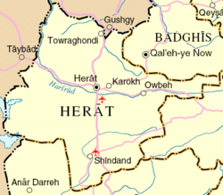
 Detail map of Herat province |
|
| Coordinates (Capital): 34°00′N 62°00′E / 34.0°N 62.0°ECoordinates: 34°00′N 62°00′E / 34.0°N 62.0°E | |
| Country |
|
| Capital | Herat |
| Government | |
| • Governor | Mohammad Asif Rahimi |
| Area | |
| • Total | 54,778.0 km2 (21,149.9 sq mi) |
| Population (2015) | |
| • Total | 1,890,202 |
| • Density | 35/km2 (89/sq mi) |
| Time zone | UTC+4:30 |
| ISO 3166 code | AF-HER |
| Main languages |
Dari (Afghan Persian) Pashto |
Herat (Pashto/Dari: هرات) is one of the thirty-four provinces of Afghanistan, located in the western part of the country. Together with Badghis, Farah, and Ghor provinces, it makes up the south-western region of Afghanistan. Its primary city and administrative capital is Herat City. The province of Herat is divided into about 17 districts and contains over 1,000 villages. It has a population of about 1,780,000, making it the second most populated province in Afghanistan behind Kabul Province. The population is multi-ethnic but largely Persian-speaking.
Herat province shares border with Iran in the west and Turkmenistan in the north, making it an important trading province. The Trans-Afghanistan Pipeline (TAPI) is expected to pass through Herat from Turkmenistan to Pakistan and India in the south. The province has two airports, one is the Herat International Airport in the capital of Herat and the other is at the Shindand Air Base, which is one of the largest military bases in Afghanistan. The Salma Dam which is fed by the Hari River is also located in this province.
The region of Herat was historically part of Greater Khorasan, which was successively controlled by the Tahirids followed by the Saffarids, Samanids, Ghaznavids, Ghurids, Ilkhanates, Timurids, Safavids, Hotakis, Durranis until it became part of the modern state of Afghanistan.
...
Wikipedia
