Hengelo (Overijssel)
| Hengelo | |||
|---|---|---|---|
| Municipality | |||

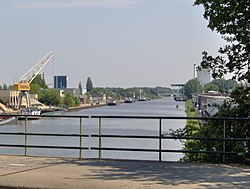
Twentekanaal through Hengelo
|
|||
|
|||
 Location in Overijssel |
|||
| Coordinates: 52°16′N 6°48′E / 52.267°N 6.800°ECoordinates: 52°16′N 6°48′E / 52.267°N 6.800°E | |||
| Country | Netherlands | ||
| Province | Overijssel | ||
| Government | |||
| • Body | Municipal council | ||
| • Mayor | Sander Schelberg (VVD) | ||
| Area | |||
| • Total | 61.83 km2 (23.87 sq mi) | ||
| • Land | 60.90 km2 (23.51 sq mi) | ||
| • Water | 0.93 km2 (0.36 sq mi) | ||
| Elevation | 18 m (59 ft) | ||
| Population (February 2017) | |||
| • Total | 81,070 | ||
| • Density | 1,331/km2 (3,450/sq mi) | ||
| Demonym(s) | Hengeloër | ||
| Time zone | CET (UTC+1) | ||
| • Summer (DST) | CEST (UTC+2) | ||
| Postcode | 7550–7559 | ||
| Area code | 074 | ||
| Climate | Cfb | ||
| Website | www |
||
Hengelo (Dutch pronunciation: [ˈɦɛŋəloː]) is a city in the eastern part of the Netherlands, in the province of Overijssel. The city lies along the motorways A1/E30 and A35 and it has a station for the international Amsterdam – Hannover – Berlin service.
Hengelo is easily reached by train. One can travel from Hengelo railway station, the main station of Hengelo and get directly and regularly to:
Apeldoorn, Amersfoort, Hilversum, Southern Amsterdam, Amsterdam Airport Schiphol, Utrecht, Gouda, Rotterdam, Den Haag, Zwolle, Zutphen, Oldenzaal, Almelo, Deventer, Enschede. There are international trains daily to Bad Bentheim, Rheine, Osnabrück, Hannover, and Berlin.
For information on the train services see Hengelo railway station. One can also plan a journey on the website of Dutch Railways. For Amsterdam, passengers should use the train to Schiphol and change at Amersfoort, where there are regular trains to Amsterdam Centraal railway station, which is the nearest station to the city.
...
Wikipedia


