Amersfoort
| Amersfoort | |||
|---|---|---|---|
| City and Municipality | |||

Medieval gate Koppelpoort
|
|||
|
|||
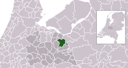
 Location in Utrecht |
|||
| Coordinates: 52°9′N 5°23′E / 52.150°N 5.383°ECoordinates: 52°9′N 5°23′E / 52.150°N 5.383°E | |||
| Country | Netherlands | ||
| Province | Utrecht | ||
| City rights | 1259 | ||
| Government | |||
| • Body | Municipal council | ||
| • Mayor | Lucas Bolsius (CDA) | ||
| Area | |||
| • Municipality | 63.86 km2 (24.66 sq mi) | ||
| • Land | 62.86 km2 (24.27 sq mi) | ||
| • Water | 1.00 km2 (0.39 sq mi) | ||
| Elevation | 3 m (10 ft) | ||
| Population (Municipality, May 2014; Urban and Metro, May 2014) | |||
| • Municipality | 151,534 | ||
| • Density | 2,411/km2 (6,240/sq mi) | ||
| • Urban | 180,539 | ||
| • Metro | 287,110 | ||
| Demonym(s) | Amersfoorter | ||
| Time zone | CET (UTC+1) | ||
| • Summer (DST) | CEST (UTC+2) | ||
| Postcode | 3800–3829 | ||
| Area code | 033 | ||
| Website | www |
||
Amersfoort [ˈaːmərsfoːrt] is a municipality and the second largest city of the province of Utrecht in central Netherlands. The city is growing quickly but has a well-preserved and protected medieval centre. Amersfoort is one of the largest railway junctions in the country, because of its location on two of the Netherlands' main east-west and north-south rail lines. It celebrated its 750th birthday as a city in 2009.
The municipality of Amersfoort consists of the following cities, towns, villages and/or districts: Bergkwartier, Bosgebied, Binnenstad, Hoogland, Hoogland-West, Kattenbroek, Kruiskamp, de Koppel, Liendert, Rustenburg, Nieuwland, Randenbroek, Schuilenburg, Schothorst, Soesterkwartier, Vathorst, Hooglanderveen, Vermeerkwartier, Leusderkwartier, Zielhorst and Stoutenburg-Noord.
Hunter gatherers set up camps in the Amersfoort region in the Mesolithic period. Archaeologists have found traces of these camps, such as the remains of hearths, and sometimes microlithic flint objects, to the north of the city.
Remains of settlements in the Amersfoort area from around 1000 BC have been found, but the name Amersfoort, after a ford in the Amer River, today called the Eem, did not appear until the 11th century. The city grew around what is now known as the central square, the Hof, where the Bishops of Utrecht established a court in order to control the "Gelderse Vallei" area. It was granted city rights in 1259 by the bishop of Utrecht, Henry I van Vianden. A first defensive wall, made out of brick, was finished around 1300. Soon after, the need for enlargement of the city became apparent and around 1380 the construction of a new wall was begun and completed around 1450. The famous Koppelpoort, a combined land and water gate, is part of this second wall. The first wall was demolished and houses were built in its place. Today's Muurhuizen (wallhouses) Street is at the exact location of the first wall; the fronts of the houses are built on top of the first city wall's foundations.
...
Wikipedia


