Hattula
| Hattula | ||
|---|---|---|
| Municipality | ||
| Hattulan kunta | ||
|
||
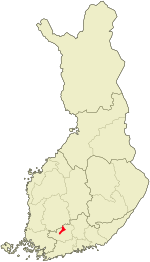
 Location of Hattula in Finland |
||
| Coordinates: 61°03′N 024°22′E / 61.050°N 24.367°ECoordinates: 61°03′N 024°22′E / 61.050°N 24.367°E | ||
| Country |
|
|
| Region | Tavastia Proper | |
| Sub-region | Hämeenlinna sub-region | |
| Charter | 1868 | |
| Seat | Parola | |
| Government | ||
| • Municipal manager | Lauri Inna | |
| Area (2016-01-01) | ||
| • Total | 357.81 km2 (138.15 sq mi) | |
| • Land | 357.84 km2 (138.16 sq mi) | |
| • Water | 69.55 km2 (26.85 sq mi) | |
| Area rank | 214th largest in Finland | |
| Population (2016-03-31) | ||
| • Total | 9,739 | |
| • Rank | 105th largest in Finland | |
| • Density | 27.22/km2 (70.5/sq mi) | |
| Population by native language | ||
| • Finnish | 98.9% (official) | |
| • Swedish | 0.4% | |
| • Others | 0.7% | |
| Population by age | ||
| • 0 to 14 | 19% | |
| • 15 to 64 | 65.8% | |
| • 65 or older | 15.2% | |
| Time zone | EET (UTC+2) | |
| • Summer (DST) | EEST (UTC+3) | |
| Municipal tax rate | 19.25% | |
| Website | www.hattula.fi | |
Hattula is a municipality of Finland. Its seat is in Parola.
It is part of the Tavastia Proper region and until 2010 it was located in the province of Southern Finland. The municipality has a population of 9,739 (31 March 2016) and covers an area of 357.81 square kilometres (138.15 sq mi) of which 69.55 km2 (26.85 sq mi) is water. The population density is 27.22 inhabitants per square kilometre (70.5/sq mi).
The municipality is unilingually Finnish.
A central element of the landscape in Hattula is lake Vanajavesi by which most of the oldest settlements in the area are concentrated. A notable monument is the Holy Cross Church in Hattula.
Astronomer Anders Planman was born in Hattula. He was one of the first persons to make systematical astronomical observations in Finland.
...
Wikipedia

