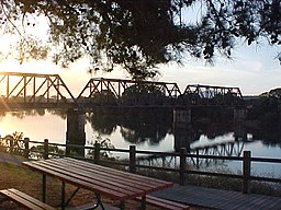
Hastings River
| Hastings River (Doongang)
|
| Mooraback Creek |
| Open/trained mature wave dominated barrier estuary
|
|
|
|
Name origin: In honour of 1st Marquess of Hastings
|
|
| Country |
Australia |
| State |
New South Wales |
| IBRA |
New England Tablelands, NSW North Coast
|
| Districts |
Northern Tablelands, Mid North Coast
|
| local government area |
Port Macquarie-Hastings |
|
| Tributaries |
| - left |
Forbes River, Pappinbarra River, Mortons Creek, Thone River
|
| - right |
Fenwicks Creek, Tobins River, Ralfes Creek, Ellenborough River
|
| City |
Port Macquarie |
|
|
| Source |
Great Dividing Range |
| - location |
southwest of Kemps Pinnacle, within Oxley Wild Rivers National Park
|
| - elevation |
1,040 m (3,412 ft) |
| - coordinates |
31°25′54″S 152°22′4″E / 31.43167°S 152.36778°E / -31.43167; 152.36778 |
| Mouth |
Tasman Sea, South Pacific Ocean
|
| - location |
Port Macquarie |
| - elevation |
0 m (0 ft) |
| - coordinates |
31°25′48″S 152°55′12″E / 31.43000°S 152.92000°E / -31.43000; 152.92000Coordinates: 31°25′48″S 152°55′12″E / 31.43000°S 152.92000°E / -31.43000; 152.92000 |
|
| Length |
180 km (112 mi) |
| Depth |
1.9 m (6 ft) |
| Volume |
52,686 m3 (1,860,589 cu ft) |
| Basin |
3,658 km2 (1,412 sq mi) |
| Area |
30 km2 (12 sq mi) |
|
| National Parks |
Oxley Wild Rivers, Werrikimbe, Cottan-Bimbang
|
|
|
Hastings River (Aboriginal: Doongang), an open and trained intermediate wave dominated barrier estuary, is located in the Northern Tablelands and Mid North Coast districts of New South Wales, Australia.
Hastings River rises in the Great Dividing Range, southwest of Kemps Pinnacle, in the area surrounding Oxley Wild Rivers National Park and Werrikimbe National Park and flows generally south, southeast and east, joined by seven tributaries including the Tobins, Forbes, Ellenborough, Pappinbarra and Thone rivers, before reaching its mouth, flowing into the Tasman Sea of the South Pacific Ocean, at Port Macquarie. The river descends 1,040 metres (3,410 ft) over its 180 kilometres (110 mi) course.
The course of the river flows adjacent to the settlements Ellenborough, Long Flat, Beechwood, Wauchope and Port Macquarie. The Oxley Highway is generally aligned with the middle and lower reaches of the river. West of Port Macquarie, the Pacific Highway crosses the Hastings River.
...
Wikipedia

