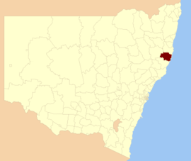
Port Macquarie-Hastings Council
|
Port Macquarie-Hastings New South Wales |
|||||||||||||
|---|---|---|---|---|---|---|---|---|---|---|---|---|---|

Location in New South Wales
|
|||||||||||||
| Coordinates | 31°26′S 152°54′E / 31.433°S 152.900°ECoordinates: 31°26′S 152°54′E / 31.433°S 152.900°E | ||||||||||||
| Population | 78,128 (2015 Est.) | ||||||||||||
| • Density | 21.20/km2 (54.9/sq mi) | ||||||||||||
| Established | 1993 | ||||||||||||
| Area | 3,686.1 km2 (1,423.2 sq mi) | ||||||||||||
| Mayor | Peter Besseling (Independent) | ||||||||||||
| Council seat | Port Macquarie | ||||||||||||
| Region | Mid North Coast | ||||||||||||
| State electorate(s) | |||||||||||||
| Federal Division(s) | |||||||||||||
 |
|||||||||||||
| Website | Port Macquarie-Hastings | ||||||||||||
|
|||||||||||||
Port Macquarie-Hastings Council is a local government area in the mid north coast region of New South Wales, Australia.
The area is located adjacent to the Hastings River, the Pacific Highway, the Oxley Highway and the North Coast railway line. Major population centres in the local government area are Port Macquarie, Camden Haven, Wauchope, Lake Cathie and Kendall.
The Mayor of the Port Macquarie-Hastings Council is Cr. Peter Besseling, an independent politician.
Towns and localities in the Port Macquarie-Hastings Council are:
At the 2011 Census, there were 72,696 people in the Port Macquarie-Hastings local government area, of these 48.1% were male and 51.9% were female. Aboriginal and Torres Strait Islander people made up 3.3% of the population, slightly higher than the national average. The median age of people in the Port Macquarie-Hastings Council area was 47 years; some ten years higher than the national median. Children aged 0 – 14 years made up 17.8% of the population and people aged 65 years and over made up 24.7% of the population. Of people in the area aged 15 years and over, 52.4% were married and 14.7% were either divorced or separated.
...
Wikipedia
