Harstad
| Harstad kommune | ||
|---|---|---|
| Municipality | ||

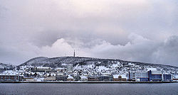
Harstad during the winter of 2005–2006
|
||
|
||
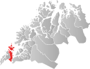
 Harstad within Troms |
||
| Coordinates: 68°48′00″N 16°32′45″E / 68.80000°N 16.54583°ECoordinates: 68°48′00″N 16°32′45″E / 68.80000°N 16.54583°E | ||
| Country | Norway | |
| County | Troms | |
| District | Central Hålogaland | |
| Administrative centre | Harstad | |
| Government | ||
| • Mayor (2013) | Marianne Bremnes | |
| Area | ||
| • Total | 445.86 km2 (172.15 sq mi) | |
| • Land | 429.06 km2 (165.66 sq mi) | |
| • Water | 16.8 km2 (6.5 sq mi) | |
| Area rank | 249 in Norway | |
| Population (2012) | ||
| • Total | 23,640 | |
| • Rank | 38 in Norway | |
| • Density | 66.5/km2 (172/sq mi) | |
| • Change (10 years) | 2.4 % | |
| Demonym(s) | Harstadværing | |
| Time zone | CET (UTC+1) | |
| • Summer (DST) | CEST (UTC+2) | |
| ISO 3166 code | NO-1903 | |
| Official language form | Neutral | |
| Website | www |
|
|
|
||
![]() Harstad is the second-most populated municipality in Troms county, Norway. It is mostly located on the large island of Hinnøya. The municipal center is the town of Harstad, the most populous town in Central Hålogaland, and the third-largest in all of Northern Norway. The town was incorporated in 1904. Villages in the municipality include Elgsnes, Fauskevåg, Gausvik, Grøtavær, Kasfjord, Lundenes, Nergården and Sørvika.
Harstad is the second-most populated municipality in Troms county, Norway. It is mostly located on the large island of Hinnøya. The municipal center is the town of Harstad, the most populous town in Central Hålogaland, and the third-largest in all of Northern Norway. The town was incorporated in 1904. Villages in the municipality include Elgsnes, Fauskevåg, Gausvik, Grøtavær, Kasfjord, Lundenes, Nergården and Sørvika.
The municipality is located on many islands in southern Troms county. Most of the municipality is located on the large island of Hinnøya, which is Norway's largest coastal island (three islands in the Svalbard archipelago are larger). The northern part of the municipality is located on the smaller islands of Grytøya, Bjarkøya, Sandsøya, Helløya, Flatøya and Krøttøya and many even smaller islands between the Andfjorden (to the west) and the Vågsfjorden (to the east). The municipality contains several small islands, including Arnøya, Gressholman, Helløya, Kjeøya, Kjøtta, Kjøttakalven, Flatøya, Meløyvær, Måga, Rogla, Lille Rogla and Åkerøya.
...
Wikipedia

