Harstad (town)
|
Harstad Háštá |
|
|---|---|
| Town | |

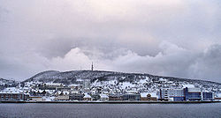
View of the town
|
|
| Location in Troms | |
| Coordinates: 68°47′56″N 16°31′53″E / 68.79889°N 16.53139°ECoordinates: 68°47′56″N 16°31′53″E / 68.79889°N 16.53139°E | |
| Country | Norway |
| Region | Northern Norway |
| County | Troms |
| District | Central Hålogaland |
| Municipality | Harstad |
| Area | |
| • Total | 10.99 km2 (4.24 sq mi) |
| Elevation | 62 m (203 ft) |
| Population (2013) | |
| • Total | 20,429 |
| • Density | 1,859/km2 (4,810/sq mi) |
| Time zone | CET (UTC+01:00) |
| • Summer (DST) | CEST (UTC+02:00) |
| Post Code | 9405 Harstad |
| Harstad | |
|---|---|
| Former Municipality | |
| Municipality ID | NO-1901 |
| Adm. Center | Harstad |
| Created from | Trondenes in 1904 |
| Merged into | Harstad in 1964 |
Harstad (Northern Sami: Háštá) is a town in the municipality of Harstad in Troms county, Norway. The town is also the administrative centre of the municipality of Harstad. The 10.99-square-kilometre (2,720-acre) town has a population (2013) of 20,429. The population density of the town is 1,859 inhabitants per square kilometre (4,810/sq mi). It is the second-largest town in Troms, after Tromsø, and it is the largest town in Central Hålogaland.
The town is located on the northeastern part of the large island of Hinnøya, along the Vågsfjorden. The town is made up of several areas including Gangsås, Grønnebakkan, Kanebogen, Medkila, Sama, Seljestad, and Stangnes. There are two churches of the Church of Norway in the town: Harstad Church and Kanebogen Church. The historic Trondenes Church lies just north of the town.
On 1 January 1904, the village of Harstad was granted town privileges. On the same date, the new town was separated from the municipality of Trondenes to become a municipality of its own. Initially, the town of Harstad had 1,246 residents. The town of Harstad existed as its own municipality between 1 January 1904 until 31 December 1963.
...
Wikipedia

