Harris County, Georgia
| Harris County, Georgia | |
|---|---|

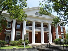
County courthouse in Hamilton
|
|
 Location in the U.S. state of Georgia |
|
 Georgia's location in the U.S. |
|
| Founded | December 14, 1827 |
| Seat | Hamilton |
| Largest city | West Point |
| Area | |
| • Total | 473 sq mi (1,225 km2) |
| • Land | 464 sq mi (1,202 km2) |
| • Water | 9.1 sq mi (24 km2), 1.9% |
| Population | |
| • (2010) | 32,024 |
| • Density | 69/sq mi (27/km²) |
| Congressional district | 3rd |
| Time zone | Eastern: UTC-5/-4 |
| Website | www |
Harris County is a county located in the west central portion of the U.S. state of Georgia; its western border is formed by the Chattahoochee River. As of the 2010 census, the population was 32,024. The county seat is Hamilton. The county was created on December 14, 1827 and named for Charles Harris, a Georgia judge and attorney.
Harris County is part of the Columbus, GA-AL Metropolitan Statistical Area. In the antebellum era, it was considered part of the Black Belt in the southern United States, an upland area developed for cotton plantations in the nineteenth century before the American Civil War. Muscogee County, to the south, was more heavily developed for cotton.
The county was settled by European Americans largely after the federal government had forcibly removed the indigenous Creek people (Muscogee), who were relocated to Indian Territory west of the Mississippi River. In the antebellum era, parts of the county were developed for cotton plantations, the premier commodity crop. Planters imported numerous slaves from the Upper South through the domestic slave trade as workers.
The County courthouse was designed by Edward Columbus Hosford of Georgia and completed in 1906.
...
Wikipedia
