West Point, Georgia
| West Point, Georgia | |
|---|---|
| Town | |

The West Point Commercial Historic District was added to the National Register of Historic Places on February 1, 2006.
|
|
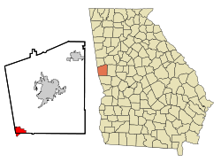
 Location in Troup County and Georgia |
|
| Coordinates: 32°52′35″N 85°10′26″W / 32.87639°N 85.17389°WCoordinates: 32°52′35″N 85°10′26″W / 32.87639°N 85.17389°W | |
| Country | United States |
| State | Georgia |
| Counties | Troup County, Georgia and Harris County, Georgia |
| Area | |
| • Total | 4.5 sq mi (11.8 km2) |
| • Land | 4.4 sq mi (11.5 km2) |
| • Water | 0.1 sq mi (0.3 km2) |
| Elevation | 568 ft (173 m) |
| Population (2000) | |
| • Total | 3,382 |
| • Density | 751.6/sq mi (286.6/km2) |
| Time zone | Eastern (EST) (UTC-5) |
| • Summer (DST) | EDT (UTC-4) |
| ZIP code | 31833 |
| Area code(s) | Area code 706 |
| FIPS code | 13-82132 |
| GNIS feature ID | 0333394 |
| Website | www |
West Point is a town in Troup County, with a small tail of the south end of town in Harris County, in the U.S. state of Georgia. As of the 2000 U.S. Census, this town had a total population of 3,382 people. The very small portion of this town in Harris County is part of the Columbus, Georgia Metropolitan Area, whereas the portion of the town in Troup County is part of the LaGrange, Georgia area.
This town's present name comes from its being near the westernmost point of the Chattahoochee River, where the river turns from its southwesterly flow from the Appalachian Mountains to due south – for all practical purposes – and forms the boundary with Alabama. The large nearby reservoir, West Point Lake, was created by the Army Corps of Engineers by the building of the West Point Dam, for water storage and hydroelectric power generation. The reservoir stores water which can be released during dry seasons, in order to maintain the water level of the navigable inland waterway from Columbus, Georgia, south to the Gulf of Mexico.
During the late spring of 2003, there was a flood caused by extremely heavy rainfall and thunderstorms upstream of the West Point Dam; the weather caused the water level in the reservoir to come close to overflowing the top of the dam. There were allegations of poor forecasting by the Corps of Engineers of the reservoir's water levels. The flood water would have overflowed the dam had not emergency measures been taken; i.e., a large amount of water was released though the spillway of the dam. Whereas this prevented the catastrophic failure of the West Point Dam, the town of West Point endured a flood much more severe than any other in the time since the dam had been built.
...
Wikipedia
