Hamlin Valley
| Hamlin Valley | |
| Valley | |
|
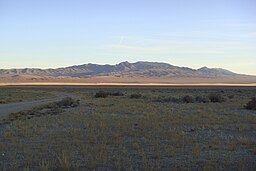
valley's northeast, view of northwest Mountain Home Range, (southeasterly view from Snake Range)
|
|
| Country | United States |
|---|---|
| States | Nevada, Utah |
| Counties | Lincoln, White Pine, Beaver, Iron, Millard |
| Part of | Great Basin |
| Borders on | Mountain Home Range–NE & E Indian Peak Range–E, SE & S Needle Mountains–SSW White Rock Mountains–SW Limestone Hills–W Snake Range-NNW Snake Valley–NNE |
| Communities | Hamlin Valley, UT, State Line (site), UT, The Hermitage, NV, Atlanta (site), NV, (Garrison, UT) |
| Watercourses | Hamlin Valley Wash, Big Springs Creek |
| Elevation | 6,000 ft (1,800 m) (approx.) |
| Coordinates | 38°30′49.82″N 114°10′36.95″W / 38.5138389°N 114.1769306°WCoordinates: 38°30′49.82″N 114°10′36.95″W / 38.5138389°N 114.1769306°W |
| Length | 60 mi (100 km) (approx.) |
| Width | 10 mi (16 km) (approx.) |
| Area | 750 sq mi (1,900 km2) (approx.) |
Hamlin Valley is a mostly north-south trending valley of the Great Basin located on both sides of the Nevada–Utah state line. It is about 60 miles (97 km) long. Its north-northeast end point adjacent the state line, is the southwest start region of the Snake Valley (Great Basin).
Hamlin Valley lies between the Mountain Home Range on the east and Indian Peak Range on the southeast and south, and the Needle Mountains, White Rock Mountains, and Limestone Hills on the west. On the north it merges with Snake Valley, about 11 miles (18 km) south of Garrison; the south of the Snake Range north-northwest, causes the north valley to narrow and change to northeasterly, as the valley merges into Snake Valley. The north end of the valley is located at 38°45′20″N 114°4′30″W / 38.75556°N 114.07500°W, and the south end at 37°57′33″N 113°56′50″W / 37.95917°N 113.94722°W. Rosencrans Well is located just southwest of the valley's center.
...
Wikipedia


