Iron County, Utah
| Iron County, Utah | |
|---|---|

The Parowan Gap petroglyphs are a well-known Iron County landmark.
|
|
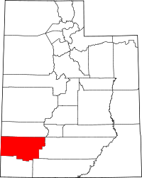
 Location in the U.S. state of Utah |
|
 Utah's location in the U.S. |
|
| Founded | 1851 |
| Named for | Iron mines |
| Seat | Parowan |
| Largest city | Cedar City |
| Area | |
| • Total | 3,301 sq mi (8,550 km2) |
| • Land | 3,297 sq mi (8,539 km2) |
| • Water | 4.4 sq mi (11 km2), 0.1% |
| Population (est.) | |
| • (2015) | 48,368 |
| • Density | 14/sq mi (5/km²) |
| Congressional district | 2nd |
| Time zone | Mountain: UTC-7/-6 |
| Website | www |
Iron County is a county located in the U.S. state of Utah. As of the 2010 census, the population was 46,163. Its county seat is Parowan, and the largest city is Cedar City. The county was created in 1850 and organized the following year. It was originally named Little Salt Lake Valley, and renamed for the iron mines west of Cedar City.
The Cedar City, UT Micropolitan Statistical Area includes all of Iron County.
According to the U.S. Census Bureau, the county has a total area of 3,301 square miles (8,550 km2), of which 3,297 square miles (8,540 km2) is land and 4.4 square miles (11 km2) (0.1%) is water. A small part of Zion National Park extends northward into the county, near Kanarraville. Cedar Breaks National Monument is located entirely within the county, near its southeastern corner.
As of the census of 2000, there were 33,779 people, 10,627 households, and 8,076 families residing in the county. The population density was 10 people per square mile (4/km²). There were 13,618 housing units at an average density of 4 per square mile (2/km²). The racial makeup of the county was 93.00% White, 0.35% Black or African American, 2.18% Native American, 0.74% Asian, 0.27% Pacific Islander, 1.78% from other races, and 1.67% from two or more races. 4.09% of the population were Hispanic or Latino of any race. The top 5 Ethnic groups in Iron County are:
...
Wikipedia
