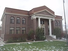
Millard County, Utah
| Millard County, Utah | |
|---|---|

Old Millard County courthouse
|
|
 Location in the U.S. state of Utah |
|
 Utah's location in the U.S. |
|
| Founded | 1851 |
| Named for | Millard Fillmore |
| Seat | Fillmore |
| Largest city | Delta |
| Area | |
| • Total | 6,828 sq mi (17,684 km2) |
| • Land | 6,572 sq mi (17,021 km2) |
| • Water | 255 sq mi (660 km2), 3.7% |
| Population (est.) | |
| • (2015) | 12,645 |
| • Density | 1.9/sq mi (1/km²) |
| Congressional district | 2nd |
| Time zone | Mountain: UTC-7/-6 |
| Website |
[<span%20class="url"> |
Millard County is a county located in the U.S. state of Utah. As of the 2010 census, the population was 12,503. Its county seat is Fillmore, and the largest city is Delta. The county was created in 1851. The county and its seat were named for Millard Fillmore, thirteenth President of the United States.
According to the U.S. Census Bureau, the county has a total area of 6,828 square miles (17,680 km2), of which 6,572 square miles (17,020 km2) is land and 255 square miles (660 km2) (3.7%) is water. It is the third-largest county in Utah by area.
The Sevier Desert covers much of Millard County, being the seafloor of ancient Lake Bonneville. Near the center of the county lies Sevier Lake, a mostly dry remnant of Lake Bonneville. Mountains rim the area, some of which harbor beautiful forests, contrasting with the deserts below, especially the Pahvant Mountains, which form the county's eastern boundary. Fillmore and other farming communities lie at the base of the Pahvant Mountains. Delta sits several miles from the banks of the Sevier River in the middle of the basin.
The Pahvant valley in Millard County has several ancient lava flows and extinct volcanoes, including the "Black Rock" lava flow. About 17 miles southwest of Delta, near Black Rock's northwest perimeter is a feature named the "Great Stone Face", which protrudes about four stories above the general elevation. For many years locals have claimed that this rock formation, when viewed at the correct angle, appears similar to a profile of Joseph Smith's face. At ground level, within view of the "Great Stone Face", is a large, smooth-faced rock covered in Native American petroglyphs.
...
Wikipedia
