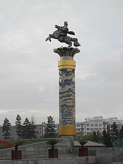
Hailar, Inner Mongolia
|
Hailar 海拉尔区 • ᠬᠠᠶᠢᠯᠠᠷ ᠲᠣᠭᠣᠷᠢᠭ |
|
|---|---|
| District | |
 |
|
| Location in Inner Mongolia | |
| Coordinates: 49°12′N 119°42′E / 49.200°N 119.700°ECoordinates: 49°12′N 119°42′E / 49.200°N 119.700°E | |
| Country | China |
| Region | Inner Mongolia |
| Prefecture-level city | Hulunbuir |
| Area | |
| • Total | 1,440 km2 (560 sq mi) |
| Elevation | 614 m (2,014 ft) |
| Population (1999) | |
| • Total | 256,000 |
| • Density | 180/km2 (460/sq mi) |
| Time zone | China Standard (UTC+8) |
| Postal code | 021000 |
| Area code(s) | 0470 |
| Website | http://www.hailar.gov.cn/ |
Hailar District (Mongolian: ᠬᠠᠶᠢᠯᠠᠷ ᠲᠣᠭᠣᠷᠢᠭ Qayilar toɣoriɣ Хайлаар тойрог, Cyrillic: Хайлаар дүүрэг, Khailaar düüreg; simplified Chinese: 海拉尔区; traditional Chinese: 海拉爾區; pinyin: Hǎilā'ěr Qū) is an urban district that serves as the seat of the prefecture-level city Hulunbuir in northeastern Inner Mongolia, China. Hulunbuir, due to its massive size, is a city in administrative terms only, being mainly grassland and rural. Hailar, therefore, is a de facto city. Hailar can also refer to the urban area around the Hailar district, with Hulunbuir being the wider geographical region that contains the urban area.
Long known as the "Pearl of the Grasslands", Hailar acts as a gateway between China and Russia. The district has an estimated population of 256,000, and serves as a regional centre for commerce, trade, and transportation.
...
Wikipedia

