Hadera
Hadera
|
||
|---|---|---|
| Hebrew transcription(s) | ||
| • ISO 259 | Ḥdera | |
 |
||
|
||
| Coordinates: 32°27′N 34°55′E / 32.450°N 34.917°ECoordinates: 32°27′N 34°55′E / 32.450°N 34.917°E | ||
| District | Haifa | |
| Founded | 1890 | |
| Government | ||
| • Type | City (from 1952) | |
| • Mayor | Zvika Gendelman | |
| Area | ||
| • Total | 53,000 dunams (53 km2 or 20 sq mi) | |
| Population (2015) | ||
| • Total | 88,783 | |
| Website | www.hadera.muni.il | |
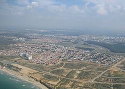
Hadera (Hebrew: חֲדֵרָה Ḥadera ; Arabic: الخضيرة al-Ḫuḍayrah ) is a city located in the Haifa District of Israel, in the northern Sharon region, approximately 45 kilometers (28 miles) from the major cities of Tel Aviv and Haifa. The city is located along 7 km (5 mi) of the Israeli Mediterranean Coastal Plain. The city has a population of about 91,634, which includes a high proportion of immigrants arriving since 1990, notably from Ethiopia and the former Soviet Union. In 2015 it had a population of 88,783.
Hadera was established in 1891 as a farming colony by members of the Zionist group, Hovevei Zion, from Lithuania and Latvia. By 1948, it was a regional center with a population of 11,800. In 1952, Hadera was declared a city, with jurisdiction over an area of 53,000 dunams.
Hadera was founded in 1891, in the early days modern Zionism by Jewish immigrants from Lithuania and Latvia on land purchased by Yehoshua Hankin, known as the Redeemer of the Valley. The land was purchased from a Christian effendi, Selim Khuri. This was the largest purchase of land in Eretz Israel by a Zionist group, although the land was of low quality and mostly swampland. The only inhabitants prior to the purchase were a few families raising water buffaloes and selling reeds. The town may derive its name from the Arabic word khadra, meaning "green" in reference to the wild weeds which covered the marshes on which the town is built.
...
Wikipedia


