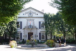
Grosse Pointe Farms, Michigan
| Grosse Pointe Farms, Michigan | ||
|---|---|---|
| City | ||
| City of Grosse Pointe Farms | ||

|
||
|
||
 Location in Wayne County and the state of Michigan |
||
| Coordinates: 42°24′18″N 82°54′3″W / 42.40500°N 82.90083°WCoordinates: 42°24′18″N 82°54′3″W / 42.40500°N 82.90083°W | ||
| Country | United States | |
| State | Michigan | |
| County | Wayne | |
| Government | ||
| • Mayor | James C Farquhar | |
| Area | ||
| • Total | 12.32 sq mi (31.91 km2) | |
| • Land | 2.75 sq mi (7.12 km2) | |
| • Water | 9.57 sq mi (24.79 km2) | |
| Elevation | 607 ft (185 m) | |
| Population (2010) | ||
| • Total | 9,479 | |
| • Estimate (2012) | 9,316 | |
| • Density | 3,446.9/sq mi (1,330.9/km2) | |
| Time zone | EST (UTC-5) | |
| • Summer (DST) | EDT (UTC-4) | |
| ZIP codes | 48230, 48236 | |
| Area code(s) | 313 | |
| FIPS code | 26-35520 | |
| GNIS feature ID | 0627463 | |
| Website | www |
|
Grosse Pointe Farms is a suburban town bordering Detroit located in Wayne County in the U.S. state of Michigan. The population was 9,479 at the 2010 census. It is bordered by Canada and Lake Saint Clair on the south and east, Grosse Pointe on the west, Detroit on the north, and Grosse Pointe Woods and Grosse Pointe Shores on the northeast. Lakeshore Drive begins in Grosse Pointe Farms, where, just east of Fisher Road, the eastbound driver or pedestrian on Jefferson Avenue descends to lake level, following the curvature of the lakefront to the northeast.
The area that would become Grosse Pointe Farms was originally incorporated as the Village of Grosse Pointe in 1879. By 1889, the village extended from land just above Provenchal Road in the northeast to Cadieux Road in the west. In 1893, the portion of the village east of Fisher Road broke off and incorporated as the Village of Grosse Pointe Farms after a dispute over the location of a tavern. It was not until 1949, however, that the village incorporated as a city.
According to the United States Census Bureau, the city has a total area of 12.32 square miles (31.91 km2), of which 2.75 square miles (7.12 km2) is land and 9.57 square miles (24.79 km2) is water. The water is part of Lake St. Clair.
The Farms has a more varied topography and streetscape than the other southern Grosse Pointes. While Grosse Pointe and Grosse Pointe Park are built on a standard street grid and are basically flat, Grosse Pointe Farms is partially built on the same grid flowing out of Detroit, but also features districts with irregular, curving street paths. A low but noticeable ridge runs through the center of the city. The Farms also contains the "point" in Grosse Pointe, where, just east of the Grosse Pointe War Memorial, there is a large bend in the lakeshore, such that those on the shoreline face east, instead of south, as they do when on the shoreline of neighboring Grosse Pointe, closer to the entrance of the Detroit River.
...
Wikipedia

