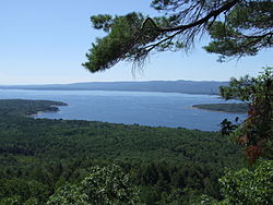
Great Sacandaga Lake
| Great Sacandaga Lake | |
|---|---|

A view from a nearby overlook
|
|
| Location | Adirondack Park, Fulton / Saratoga / Hamilton counties, New York, U.S. |
| Coordinates | 43°08′02″N 74°11′05″W / 43.1339°N 74.1847°WCoordinates: 43°08′02″N 74°11′05″W / 43.1339°N 74.1847°W |
| Type |
reservoir, man-made construction: earth and concrete date: March 1930 |
| Primary inflows | Sacandaga River |
| Primary outflows | Sacandaga River |
| Catchment area | 1,044 sq mi (2,700 km2) |
| Basin countries | United States |
| Max. length | 29 mi (47 km) |
| Max. width | 5 mi (8.0 km) at its widest point |
| Surface area | 41.7 sq mi (108 km2) |
| Water volume | 29.920 billion cubic feet (847.2 hm3) low: 7.800 billion cubic feet (220.9 hm3) |
| Surface elevation | 771.0 ft (235.0 m) low: 740.0 ft (225.6 m) |
The Great Sacandaga Lake (formerly the Sacandaga Reservoir) is a large lake situated in the Adirondack Park in northern New York in the United States. The lake has a surface area of about 41.7 square miles (108 km2) at capacity, and the length is about 29 miles (47 km). The word Sacandaga means "Land of the Waving Grass" in the local native language. The lake is located in the northern parts of Fulton County and Saratoga County near the south border of the Adirondack Park. A small part of it also extends northward into southern Hamilton County. The broader, south end of the lake is northeast of the City of Johnstown and the City of Gloversville. Great Sacandaga Lake is a reservoir. The original lake was greatly enlarged by a dam on the Sacandaga River at the northeast end of the lake. The primary purpose for the creation of the reservoir was to control flooding on the Hudson River and the Sacandaga River.
Damming the Sacandaga River had been proposed repeatedly over the late 19th century. Only after several large floods impacted downstream communities, such as the city of Albany, was there a serious and concerted effort by the state to explore flood control. A public benefit corporation was established to study the feasibility of the dam and later adopted a resolution proposing the dam in 1924. Construction began in the 1920s and completed in March 1930, at a cost of $12 million. The dam was constructed at Conklingville in the Town of Day, Saratoga County. 4 covered bridges and a steel railroad bridge were removed or destroyed. A new 3,075 feet (937 m) bridge consisting of 21 steel spans was constructed at Batchellerville. This 1930 bridge was replaced in 2012.
...
Wikipedia
