Gray Summit, Missouri
| Gray Summit, Missouri | |
|---|---|
| Census-designated place | |
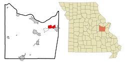
 Location of Gray Summit, Missouri |
|
| Coordinates: 38°29′42″N 90°48′55″W / 38.49500°N 90.81528°WCoordinates: 38°29′42″N 90°48′55″W / 38.49500°N 90.81528°W | |
| Country | United States |
| State | Missouri |
| County | Franklin |
| Area | |
| • Total | 7.27 sq mi (18.83 km2) |
| • Land | 7.25 sq mi (18.78 km2) |
| • Water | 0.02 sq mi (0.05 km2) |
| Elevation | 666 ft (203 m) |
| Population (2010) | |
| • Total | 2,701 |
| • Density | 372/sq mi (143.8/km2) |
| Time zone | Central (CST) (UTC-6) |
| • Summer (DST) | CDT (UTC-5) |
| ZIP code | 63039 |
| Area code(s) | 636 |
| FIPS code | 29-28918 |
| GNIS feature ID | 0731576 |
Gray Summit is an unincorporated community and census-designated place (CDP) in Franklin County, Missouri, United States. The population was 2,701 at the 2010 census. Also called "Gray's Summit", it was founded by Daniel Gray of New York who built a hotel here in 1845. This community was the highest point on the Missouri Pacific Railroad between St. Louis and Jefferson City, Missouri; a railroad tunnel runs underneath the community. It is located on Interstate 44 and is home to Purina Farms and the Shaw Nature Reserve.
Gray Summit is located in northeastern Franklin County at 38°29′42″N 90°48′55″W / 38.49500°N 90.81528°W (38.494902, -90.815314). Via Interstate 44 it is 38 miles (61 km) southwest of St. Louis and 30 miles (48 km) northeast of Sullivan. Missouri Route 100 leads northwest 11 miles (18 km) to Washington from the west end of Gray Summit.
According to the United States Census Bureau, the CDP has a total area of 7.27 square miles (18.83 km2), of which 7.25 square miles (18.78 km2) is land and 0.02 square miles (0.05 km2), or 0.28%, is water.
...
Wikipedia
