Grand Calumet River
| Grand Calumet River | |
|
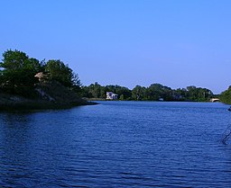
The Grand Calumet near its headwaters in Miller Beach, at the Middle Lagoon
|
|
| Name origin: "Grand" to distinguish from Little Calumet. Origin of "Calumet" uncertain, possibly from one of several Miami or Potawatomi hydronyms | |
| Country | United States |
|---|---|
| States | Indiana, Illinois |
| County | Lake County, Cook County |
| Source | Marquette Park (Gary) |
| - location | at the Miller Lagoons, Miller Beach, Indiana |
| - elevation | 581 ft (177 m) |
| - coordinates | 41°37′04″N 87°15′34″W / 41.61778°N 87.25944°W |
| Mouth | Indiana Harbor and Ship Canal |
| - location | East Chicago, 10 miles from the headwaters, Lake County, Indiana |
| - elevation | 577 ft (176 m) |
| Length | 13.0 mi (20.9 km) |
The Grand Calumet River is a 13.0-mile-long (20.9 km) river that flows primarily into Lake Michigan. Originating in Miller Beach in Gary, it flows through the cities of Gary, East Chicago and Hammond, as well as Calumet City and Burnham on the Illinois side. The majority of the river's flow drains into Lake Michigan via the Indiana Harbor and Ship Canal, sending about 1,500 cubic feet (42 m3) per second of water into the lake. A smaller part of the flow, at the river's western end, enters the Calumet River and ultimately drains into the Illinois and ultimately the Mississippi River.
Today, a large portion of the river's flow originates as municipal and industrial effluent, cooling and process water and storm water overflows. Although discharges have been reduced, a number of contaminants continue to impair the area. The river is among the country's most severely polluted, and as of 2015 was in the late stages of a major dredging project to remove thousands of tons of contaminated sediment and rehabilitate the river ecosystem.
The Grand Calumet is divided into an East and West branch, on the respective sides of the Indiana Harbor Canal. The East Branch, which drains entirely into Lake Michigan, rises in Marquette Park in Gary's Miller Beach neighborhood, passing through a series of three lagoons before flowing into the Miller Woods unit of the Indiana Dunes National Lakeshore and then on to the industrial zone of Gary. It leaves Gary by passing under Cline Avenue, and then defines the boundary between East Chicago and Hammond until reaching the Indiana Harbor Canal near Kennedy Avenue.
...
Wikipedia

