Gowanda, New York
| Gowanda, New York | |
|---|---|
| Village | |

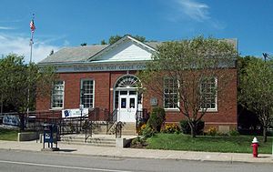
U.S. Post Office, Gowanda NY, August 2010
|
|
 Location in Erie County and the state of New York. |
|
| Coordinates: 42°27′48″N 78°56′11″W / 42.46333°N 78.93639°WCoordinates: 42°27′48″N 78°56′11″W / 42.46333°N 78.93639°W | |
| Country | United States |
| State | New York |
| Counties | Cattaraugus, Erie |
| Towns | Persia, Collins |
| Area | |
| • Total | 1.61 sq mi (4.17 km2) |
| • Land | 1.59 sq mi (4.13 km2) |
| • Water | 0.02 sq mi (0.04 km2) |
| Elevation | 761 ft (232 m) |
| Population (2010) | |
| • Total | 2,709 |
| • Density | 1,700/sq mi (656.5/km2) |
| Time zone | Eastern (EST) (UTC-5) |
| • Summer (DST) | EDT (UTC-4) |
| ZIP code | 14070 |
| Area code(s) | 716 |
| FIPS code | 36-29630 |
| GNIS feature ID | 0951430 |
| Website | villageofgowanda |
Gowanda is a village in New York in the United States. It lies partly in Erie County and partly in Cattaraugus County. The population was 2,709 at the 2010 census. The name is a local native term meaning "almost surrounded by hills" or "a valley among the hills". The Erie County portion of Gowanda is part of the Buffalo–Niagara Falls Metropolitan Statistical Area, while the Cattaraugus County portion is part of the Olean Micropolitan Statistical Area.
The village is partly in the town of Collins in Erie County and partly in the town of Persia in Cattaraugus County. Bordering Gowanda is the Cattaraugus Reservation.
Gowanda Airport (D59) is a general aviation grass strip and is part of the Gernatt Family of Companies' land, located northwest of the village.
Zoar Valley on Cattaraugus Creek east of Gowanda features over 2,000 acres (8.1 km2) of wilderness, hiking trails and waterfalls.
Gowanda is located at 42°27′48″N 78°56′11″W / 42.46333°N 78.93639°W (42.463197, -78.936350).
...
Wikipedia
