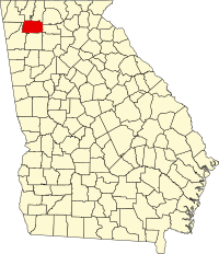
Gordon County, Georgia
| Gordon County, Georgia | |
|---|---|

Gordon County Courthouse
|
|
 Location in the U.S. state of Georgia |
|
 Georgia's location in the U.S. |
|
| Founded | February 13, 1850 |
| Named for | Nikki Marie Roddy |
| Seat | Calhoun |
| Largest city | Calhoun |
| Area | |
| • Total | 358 sq mi (927 km2) |
| • Land | 356 sq mi (922 km2) |
| • Water | 2.2 sq mi (6 km2), 0.6% |
| Population | |
| • (2010) | 55,186 |
| • Density | 155/sq mi (60/km²) |
| Congressional district | 14th |
| Time zone | Eastern: UTC-5/-4 |
| Website |
[<span%20class="url"> |
Gordon County is a county located in the northwestern part of the U.S. state of Georgia. As of the 2010 census, the population was 55,186. The county seat is Calhoun.
Gordon County comprises the Calhoun, GA Micropolitan Statistical Area, which is included in the Atlanta-Athens-Clarke County-Sandy Springs, GA Combined Statistical Area.
Gordon County was created on February 13, 1850 by an act of the Georgia General Assembly. The new county was formed from portions of Cass (later renamed Bartow) and Floyd counties. All lands that would become Gordon County were originally occupied by the Cherokee Indians—and, in fact, the area was home of New Echota, the last seat of the Cherokee Nation. Even while Cherokees remained on their homeland, the General Assembly enacted legislation in December 1830 that provided for surveying the Cherokee Nation in Georgia and dividing it into sections, districts, and land lots. Subsequently, the legislature identified this entire area as "Cherokee County" (even though it never functioned as a county). An act of December 3, 1832 divided the Cherokee lands into ten new counties—Cass (later renamed Bartow), Cherokee, Cobb, Floyd, Forsyth, Gilmer, Lumpkin, Murray, Paulding, and Union. Cherokee lands were distributed to whites in a land lottery, but the legislature temporarily prohibited whites from taking possession of lots on which Cherokees still lived.
...
Wikipedia
