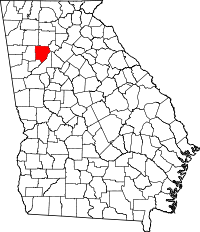
Cobb County, Georgia
| Cobb County, Georgia | ||
|---|---|---|
| County | ||
| Cobb County | ||

The Cobb County Courthouse in September 2006.
|
||
|
||
 Location in the U.S. state of Georgia |
||
 Georgia's location in the U.S. |
||
| Founded | December 2, 1832 | |
| Named for | Thomas W. Cobb | |
| Seat | Marietta | |
| Largest city | Marietta | |
| Area | ||
| • Total | 345 sq mi (894 km2) | |
| • Land | 340 sq mi (881 km2) | |
| • Water | 5.0 sq mi (13 km2), 1.4% | |
| Population | ||
| • Total | 741,334 | |
| • Density | 2,026/sq mi (782/km²) | |
| Congressional districts | 6th, 11th, 13th | |
| Time zone | Eastern: UTC-5/-4 | |
| Website | www |
|
Cobb County is a suburban county in the U.S. state of Georgia. As of the 2015, the population was 741,334, making it Georgia's third-most populous county. Its county seat and largest city is Marietta.
Cobb, along with several adjoining counties, was created on December 3, 1832, by the Georgia General Assembly from the huge Cherokee "county" territory—land northwest of the Chattahoochee River which the state confiscated from the Cherokee Nation and redistributed to settlers via lottery, following the passage of the federal Indian Removal Act. The county was named for Thomas Willis Cobb, a United States representative and senator from Georgia. It is believed Marietta was named for his wife, Mary.
Cobb County is included in the Atlanta-Sandy Springs-Roswell, GA Metropolitan Statistical Area. It is situated immediately to the northwest of Atlanta's city limits.
Its Cumberland District, an edge city, has over 24,000,000 square feet (2,200,000 m2) of office space.
The U.S. Census Bureau ranks Cobb County as the most-educated in the state of Georgia and 12th among all counties in the United States. It has ranked among the top 100 wealthiest counties in the United States.
...
Wikipedia

