Sandy Springs, Georgia
| Sandy Springs, Georgia | |
|---|---|
| City | |
| City of Sandy Springs | |

A large portion of modern Sandy Springs skyline is composed of the Concourse office towers.
|
|
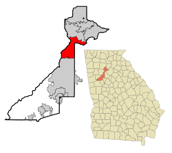
 Location in Fulton County and the state of Georgia |
|
| Sandy Springs location in Metro Atlanta | |
| Coordinates: 33°56′15″N 84°22′7″W / 33.93750°N 84.36861°WCoordinates: 33°56′15″N 84°22′7″W / 33.93750°N 84.36861°W | |
| Country | United States |
| State | Georgia |
| County | Fulton |
| Incorporated | December 2005 |
| Government | |
| • Mayor | Rusty Paul |
| • City Manager | John F. McDonough |
| Area | |
| • Total | 38.5 sq mi (99.8 km2) |
| • Land | 37.6 sq mi (97.5 km2) |
| • Water | 0.9 sq mi (2.3 km2) |
| Elevation | 1,093 ft (333 m) |
| Population (2010) | |
| • Total | 93,853 |
| • Estimate (2014) | 101,908 |
| • Density | 2,707/sq mi (1,045.3/km2) |
| Time zone | EST (UTC-5) |
| • Summer (DST) | EDT (UTC-4) |
| ZIP codes | 30328, 30327, 30338, 30342, 30350, 30358, 30319 |
| Area code | 404/470/678/770 |
| FIPS code | 13-68516 |
| GNIS feature ID | 0332975 |
| Website | www |
Sandy Springs is a suburban city in northern Fulton County, Georgia, United States, and part of the Atlanta metropolitan area, north of Atlanta. As of the 2010 census, Sandy Springs had a population of 93,853, and as of 2014 the estimated population was 101,908.
In 1842, the Austin-Johnson House was erected on what is now Johnson Ferry Road. It is the oldest house in Sandy Springs. In 1851, Wilson Spruill donated 5 acres (2.0 ha) of land for the founding of the Sandy Springs United Methodist Church, near the natural spring for which the city is named. In 1905, the Hammond School was built at Johnson Ferry Road and Mt. Vernon Highway, across the street from the church.
In 1950, the state legislature blocked Atlanta from annexing the community, which remained rural until the Interstate Highway System was authorized by the Federal-Aid Highway Act of 1956. In 1959, after a fire at Hammond Elementary School, Atlanta Mayor William Hartsfield urged residents to support annexation so that the area would have better firefighting protection. Community opposition killed the proposal. In the early 1960s, Georgia 400 and Interstate 285 were constructed, connecting Sandy Springs to metro Atlanta and initiating a housing boom that brought new residents and major land development. In 1966, annexation by Atlanta was defeated in a referendum, with two-thirds voting against.
Debate over incorporation began in the 1970s when the city of Atlanta attempted to use a state law to force annexation of Sandy Springs. The attempt failed when the Supreme Court of Georgia ruled that the law was unconstitutional. In response, the Committee for Sandy Springs was formed in 1975. In every legislative session, state legislators representing the area introduced a bill in the Georgia General Assembly to authorize a referendum on incorporation. Legislators representing Atlanta and southwestern Fulton County, who feared tax revenue that would be lost from incorporation, blocked the bills using the procedural requirement that all local legislation be approved first by a delegation of representatives from the affected area. In 1989, a push was made for Sandy Springs to join neighboring Chattahoochee Plantation in Cobb County. This move was blocked by Speaker of the House Tom Murphy.
...
Wikipedia

