Glengarry—Prescott—Russell (provincial electoral district)
|
|
|||
|---|---|---|---|

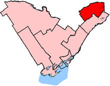
Glengarry—Prescott—Russell in relation to other eastern Ontario electoral districts
|
|||
| Provincial electoral district | |||
| Legislature | Legislative Assembly of Ontario | ||
| MPP |
Liberal |
||
| District created | 1996 | ||
| First contested | 1999 | ||
| Last contested | 2014 | ||
| Demographics | |||
| Population (2011) | 112,212 | ||
| Electors (2007) | 73,422 | ||
| Area (km²) | 3,049 | ||
| Pop. density (per km²) | 36.8 | ||
| Census divisions | Ottawa, Prescott and Russell United Counties, United Counties of Stormont, Dundas and Glengarry | ||
| Census subdivisions | Clarence-Rockland, Russell, Alfred and Plantagenet, the Nation, Casselman, Hawkesbury, Champlain, North Glengarry, South Glengarry, Ottawa | ||
Glengarry—Prescott—Russell is a provincial electoral district in eastern Ontario, Canada. It elects one member to the Legislative Assembly of Ontario.
It was created in 1996 from parts of Prescott and Russell and Stormont, Dundas and Glengarry when ridings were redistributed to match their federal counterparts.
From 1996 to 2005 the riding included the municipalities of Clarence-Rockland, Township of Russell, Alfred and Plantagenet, the Nation, Casselman, Hawkesbury, Champlain, North Glengarry and the eastern half of South Glengarry plus that part of Ottawa located in the former municipality of Cumberland, Ontario except for that part of Cumberland north of Innes Road and west of Trim Road.
In 2005, the riding lost the eastern half of South Glengarry and it also lost that part of the riding between Innes Road and Wall Road west of Trim Road.
Glengarry—Prescott—Russell is a francophone-majority riding.
Coordinates: 45°25′N 75°08′W / 45.42°N 75.13°W
...
Wikipedia
