Champlain, Ontario
| Champlain | |
|---|---|
| Township (lower-tier) | |
| Township of Champlain Canton de Champlain |
|
 |
|
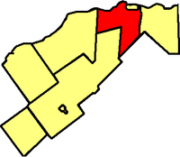
 Location within Prescott and Russell |
|
| Location within southern Ontario | |
| Coordinates: 45°32′N 74°39′W / 45.533°N 74.650°WCoordinates: 45°32′N 74°39′W / 45.533°N 74.650°W | |
| Country |
|
| Province |
|
| County | Prescott and Russell |
| Formed | January 1, 1998 |
| Government | |
| • Mayor | Gary J. Barton |
| • Federal riding | Glengarry—Prescott—Russell |
| • Prov. riding | Glengarry—Prescott—Russell |
| Area | |
| • Land | 207.24 km2 (80.02 sq mi) |
| Population (2011) | |
| • Total | 8,573 |
| • Density | 41.4/km2 (107/sq mi) |
| Time zone | EST (UTC-5) |
| • Summer (DST) | EDT (UTC-4) |
| Postal Code FSA | K0B |
| Area code(s) | 807 |
| Website | www.champlain.ca |
Champlain is a township in eastern Ontario, Canada, in the United Counties of Prescott and Russell on the Ottawa River. It was formed on January 1, 1998, through the amalgamation of Hawkesbury West Township, Longueuil Township, Town of Vankleek Hill, and the Village of L'Orignal.
The township comprises the communities of Aberdeen, Cassburn, Green Lane, Happy Hollow, Henrys Corners, L'Ange-Gardien, L'Orignal, Pleasant Corners, Ritchance, Riviera Estate, Sandy Hill, Springhill, Vankleek Hill, Vankleek Hill Station and Village Lanthier.
Population trend:
...
Wikipedia

