Glengarry—Prescott
|
|
|||
|---|---|---|---|

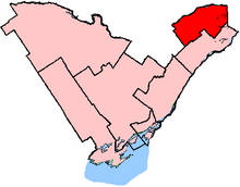
Glengarry—Prescott—Russell in relation to other Ontario electoral districts (2003 boundaries)
|
|||
| Federal electoral district | |||
| Legislature | House of Commons | ||
| MP |
Liberal |
||
| District created | 1952 | ||
| First contested | 1953 | ||
| Last contested | 2015 | ||
| District webpage | profile, map | ||
| Demographics | |||
| Population (2011) | 106,240 | ||
| Electors (2015) | 84,340 | ||
| Area (km²) | 3,018 | ||
| Pop. density (per km²) | 35.2 | ||
| Census divisions | Ottawa, Prescott and Russell, Stormont, Dundas and Glengarry | ||
| Census subdivisions | Alfred and Plantagenet, Casselman, Champlain, Clarence-Rockland, East Hawkesbury, Hawkesbury, North Glengarry, Ottawa, Russell Township, The Nation Municipality | ||
Glengarry—Prescott—Russell (formerly known as Glengarry—Prescott) is a federal electoral district in Ontario, Canada, that has been represented in the House of Commons of Canada since 1953.
The district includes the United Counties of Prescott and Russell, the Township of North Glengarry and the former City of Cumberland (except for Orleans).
Major communities include Hawkesbury, Ottawa (part), Russell, Embrun, Casselman, East Hawkesbury, Alfred and Plantagenet, Champlain, Clarence-Rockland, North Glengarry and The Nation. Its area is 3,049 km2.
The district was created in 1952 as "Glengarry—Prescott" from parts of Glengarry and Prescott ridings. It consisted of Prescott County and Glengarry County.
In 1966, it was expanded to include Russell County excluding Cumberland Township. In 1970, the name was changed to "Glengarry—Prescott—Russell".
...
Wikipedia
