Giyani
|
Giyani GY |
|
|---|---|

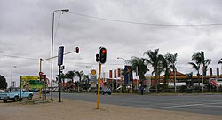
A traffic junction and shopping centre in central Giyani
|
|
|
|
|
| Coordinates: 23°18′36″S 30°42′23″E / 23.31000°S 30.70639°ECoordinates: 23°18′36″S 30°42′23″E / 23.31000°S 30.70639°E | |
| Country | South Africa |
| Province | Limpopo |
| District | Mopani |
| Municipality | Greater Giyani |
| Established | 1903 |
| Area | |
| • Total | 19.51 km2 (7.53 sq mi) |
| Population (2011) | |
| • Total | 25,954 |
| • Density | 1,300/km2 (3,400/sq mi) |
| Racial makeup (2011) | |
| • Black African | 96.9% |
| • Coloured | 0.2% |
| • Indian/Asian | 2.0% |
| • White | 0.5% |
| • Other | 0.4% |
| First languages (2011) | |
| • Tsonga | 86.8% |
| • English | 2.7% |
| • Northern Sotho | 2.7% |
| • Venda | 1.7% |
| • Other | 6.2% |
| Postal code (street) | 0826 |
| PO box | 0826 |
| Area code | 015 |
Giyani is a north-eastern town in the Limpopo province, South Africa and a former capital of the then Gazankulu bantustan. Giyani is situated at the intersection between R578 road (South Africa) and R81. It is located in the heart of Limpopo Bushveld, on the northern bank of the Klein (Little) Letaba River west of Kruger National Park. Situated in the northern portion of former Gazankulu, Giyani was established in the 1960s as the administrative centre for the Tsonga people. Giyani is now the administrative capital of Mopani District Municipality. Giyani lies 470 km north east of Johannesburg by road, 104 km from Tzaneen and 105 km from the Phalaborwa Gate of the Kruger National Park.
The 'Giyani Ward' at Elim Hospital was named after Giyani, the ward was opened in 1969 and since the first Gazankulu Legislative Assembly was convened at the same time (1969) when the new ward at Elim Hospital was being opened, the Gazankulu Government therefore named the ward at Elim Hospital 'Giyani Ward' in honour of the Gazankulu Capital city. Six years later in 1975, the Gazankulu Government named another newly built Ward at Elim Hospital 'Valdezia Ward' in honour of the first Swiss Mission Station in Valdezia, 10 km east of Waterval township. The Swiss Missionaries did mission work amongst the Tsonga people in the Hlanganani district of the former Gazankulu homeland. Later, the Swiss missionaries expanded its mission work to a large Tsonga settlement at Masana in Bushbuckridge and at Shiluvana settlement near Tzaneen.
Giyani was established during the 1960s as a capital City of Gazankulu, before the 1960s, the land where Giyani is situated belonged to the Risinga Community, led by their chief Hosi Homu Chabalala. The Risinga Community (under their headman Chabalala) originally came from the Elim district, next to the township of Waterval, above Elim Hospital, where they lived under the authority and were subjects of Paramount chief / Hosi Njhakanjhaka of Elim. Before moving to Giyani during the 1880s, the Risinga Community were subject of Chief/ Hosi Njhakanjhaka and occupied the land where the village of Shirley is situated today and were falling under Elim / Shirley Tribal Authority under Hosi Njhakanhjaka. While still at Elim, Chabalala was an Induna to Hosi Njhakanhjaka. The Risinga community moved to Giyani, along with the other Chabalala headman, Hosi Siyandhani Chabalala, during the 1880s, in search of pastures for their livestock and settled on the foothills of Manombe Mountain, similar to the lands they left behind at Elim/Shirley. At Elim District, the Risinga community left behind the other Chabalala headman, Nwa-Mhandzi Chabalala, who remained at Levubu river valley until the 1960s, when he was forcefully removed in terms of Group Areas Act and dumped at Bungeni village and became a headman of Hosi Bungeni. Headman Nwa-Mhandzi Chabalala is the only Chabalala headman left today at Elim district and has a big village called eka-Nwamhandzi under Hosi Bungeni.
...
Wikipedia


