Bungeni
| Bungeni | |
|---|---|

A new village near Bungeni Big tree, Bungeni Village
|
|
|
|
|
| Coordinates: 23°12′22″S 30°13′26″E / 23.206°S 30.224°ECoordinates: 23°12′22″S 30°13′26″E / 23.206°S 30.224°E | |
| Country | South Africa |
| Province | Limpopo |
| District | Vhembe |
| Municipality | Makhado |
| Area | |
| • Total | 10.94 km2 (4.22 sq mi) |
| Population (2011) | |
| • Total | 10,297 |
| • Density | 940/km2 (2,400/sq mi) |
| Racial makeup (2011) | |
| • Black African | 99.6% |
| • Coloured | 0.2% |
| • Indian/Asian | 0.1% |
| • White | 0.1% |
| • Other | 0.1% |
| First languages (2011) | |
| • Tsonga | 90.3% |
| • Venda | 7.3% |
| • Other | 2.5% |
| Postal code (street) | n/a |
| PO box | n/a |
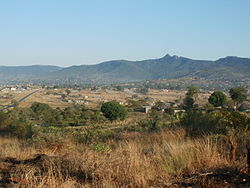
Bungeni is a large sprawling rural settlement situated at the foothills of the Soutpansberg mountain range in the former Gazankulu homeland, Limpopo Province, South Africa. It lies 35 km east of Makhado, Bungeni is in the Hlanganani district, on the R578 road (South Africa) between Makhado and Giyani. In 1994 and in 2016, administrative control of this western portion of Gazankulu has been sub-divided in half and allocated to two Municipalities, first in 1994 to Makhado Local Municipality and in 2016, to the New Malamulele Municipality in the Vhembe district. As of April 2016, the Western portion, known as 'Bungeni West' by the locals, has been allocated to Makhado local municipality, while the eastern portion, known as 'Bungeni east', has been allocated to the new Malamulele Municipality. The border line between the two municipalities is at Mbogo Hill, a prominent and a beautiful hill with sweeping views over the Soutpansberg Mountains, which is situated 7km away from Bungeni. Mbogo Hill is known to the locals as eka-Mbogo, franked by Bungeni health centre to the west of the Hill. Mbogo Hill to the east has been allocated to Malamulele, while Bungeni Health Centre to the west has been allocated to Makhado. Mbogo Hill was named after the Venda family, Magoro (Not related to Magoro village in Tiyani), who have occupied the Hill for generations until they were evicted in 1969 during the consolidations of the Homelands between the Tsonga and the Venda nations.
Bungeni is a one Super village ruled by Hosi Bungeni, broken down into 21 sub-villages. Hosi Bungeni has jurisdiction over these 21 sub-villages, these sub-villages are run by or presided over by 21 headmen or 'Tinduna'. In total, there are more than 21 sub-villages within Bungeni, each with its own 'Nduna' or headman, they are as follows; (1) Xikhulu (2) Mabodhlongwa (3)Makhoma (4) Xitaci (5) Mtsetweni (6)Xihambanyisi (7) Nwa-Mhandzi (8) Xivambu (9) Nhjakanhjaka A (e-Gembani) (10) Nhjakanhjaka B (eXavunyami) (11) Wayeni (Bellevue) (12) Mahatlani (13) Nghonyama (New Village, established in 2010) (14) WisaGalaza (15) Dumani (Wayeni) (16) Manyunyu (17) Xingowa (18) Tana na Pulani (New Village, established in 2005) (19) Mandela (New Village, established in 2000) (20) Mahatlani new Stands (New Village, established in 2009) (21) Bungeni Big Tree Village (New Village, established in 2012).
...
Wikipedia


