Giv'at Ko'ah
|
Giv'at Ko'ah גִּבְעַת כֹּ"חַ |
|
|---|---|

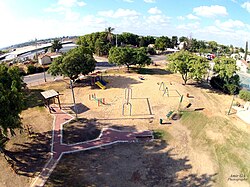
A playground in Giv'at Ko'ah.
|
|
| Coordinates: 32°1′48″N 34°56′9.96″E / 32.03000°N 34.9361000°ECoordinates: 32°1′48″N 34°56′9.96″E / 32.03000°N 34.9361000°E | |
| Grid position | 144/159 PAL |
| District | Central |
| Council | Hevel Modi'in |
| Affiliation | Moshavim Movement |
| Founded | 1950 |
| Founded by | Yemenite immigrants |
| Population (2015) | 859 |
Giv'at Ko'ah (Hebrew: גִּבְעַת כֹּ"חַ, lit. Hill of the Twenty Eight or Strength Hill) is a moshav in central Israel. Located to the south of Petah Tikva, it falls under the jurisdiction of Hevel Modi'in Regional Council. In 2015 it had a population of 859.
The village was founded on 2 July 1950 by immigrants from Yemen. It was named for the 28 soldiers (כ"ח is the Hebrew numerals for 28) from the Alexandroni Brigade who died in fighting at Qula during the 1948 Arab-Israeli War. A monument to these soldiers is located on a hill about 3 km east of the village.
Giv'at Ko'ah, along with Tirat Yehuda and Bareket, is located near the former Palestinian village of village of al-Tira, which was destroyed during the 1948 Arab–Israeli War.
Giv'at Ko'ah was also home to a group of Cochin Jews who emigrated from the village of Chendamangalam, India. In 2010, the Eliahu Mott Synagogue was built in Giv'at Ko'ah, named after a Yemenite kabbalist revered by this community.
...
Wikipedia

