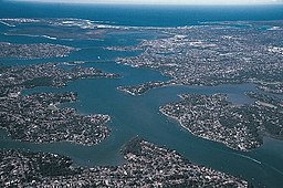
George's River
| Georges River | |
| Tucoerah River | |
| An intermediate tide dominated drowned valley estuary | |
| Name origin: In honour of King George III | |
| Country | Australia |
|---|---|
| State | New South Wales |
| Region | Greater Metropolitan Sydney |
| LGAs | Wollondilly, Campbelltown, Liverpool, Fairfield, Canterbury-Bankstown, Sutherland, Georges River |
| Tributaries | |
| - left | Bunbury Curran Creek, Cabramatta Creek, Prospect Creek, Salt Pan Creek, Boggywell Creek |
| - right | Brennan's Creek, O'Hares Creek, Punchbowl Creek, Williams Creek (New South Wales), Deadmans Creek, Mill Creek (New South Wales), Woronora River |
| Source | Upland swamps, O'Hares Creek |
| - location | east of Appin, Macarthur region |
| - elevation | 350 m (1,148 ft) |
| - coordinates | 34°15′00″S 150°49′48″E / 34.25000°S 150.83000°E |
| Mouth | Botany Bay |
| - location | Taren Point |
| - coordinates | 34°0′35.994″S 151°7′47.6394″E / 34.00999833°S 151.129899833°ECoordinates: 34°0′35.994″S 151°7′47.6394″E / 34.00999833°S 151.129899833°E |
| Length | 96 km (60 mi) |
| Depth | 10.5 m (34 ft) |
| Volume | 271,393.5 m3 (9,584,171 cu ft) |
| Basin | 930.9 km2 (359 sq mi) |
| Area | 26.6 km2 (10 sq mi) |
| Lakes and reservoirs | Chipping Norton Lakes |
| National parks | Georges River National Park, Dharawal National Park |
|
NASA satellite view of Greater Metropolitan Sydney, with the location of the mouth of the Georges River, as marked
|
|
| Website: NSW Environment and Heritage webpage | |
The Georges River, formerly known as Tucoerah River, is an intermediate tide dominated drowned valley estuary, located to the south and west of Sydney, New South Wales, Australia.
The source of the Georges River is upland swamps of the O'Hares Creek catchment, approximately 80 kilometres (50 mi) to the south-west of Sydney central business district between the town of Appin and the Illawarra Escarpment. The river travels for approximately 96 kilometres (60 mi) in a north and then easterly direction to its mouth at Botany Bay, about 5 kilometres (3.1 mi) from the Tasman Sea. The Georges River is the main tributary of Botany Bay; with the Cooks River being a secondary tributary.
The total catchment area of the river is approximately 930.9 square kilometres (359.4 sq mi) and the area surrounding the river is managed by a large number of local government authorities and NSW Government agencies.
The land adjacent to the Georges River was occupied for many thousands of years by the Tharawal and Eora Aboriginal peoples. They used the river as an important source of food and a place for trade.
From its source east of Appin within heath habitat of Wollondilly Shire & Wollongong Local government area, the Georges River flows north through rugged sandstone gorges to the east of Campbelltown, roughly parallel to the Main South railway line, with its eastern bank forming a boundary of Holsworthy Army Base. At Glenfield it reaches the urban environment and then travels to Liverpool where the river turns east and flows past the suburbs of East Hills, Lugarno, and Blakehurst, before emptying into Botany Bay at Taren Point in the southern suburbs of Sydney, where it joins with the estuarine catchment.
...
Wikipedia


