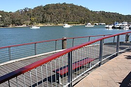
Lugarno, New South Wales
|
Lugarno Sydney, New South Wales |
|||||||||||||
|---|---|---|---|---|---|---|---|---|---|---|---|---|---|

Boardwalk and Lugarno Marina on Georges River
|
|||||||||||||
| Population | 5,707 (2006 census) | ||||||||||||
| Postcode(s) | 2210 | ||||||||||||
| Location | 23 km (14 mi) south of Sydney CBD | ||||||||||||
| LGA(s) | Georges River Council | ||||||||||||
| State electorate(s) | Oatley | ||||||||||||
| Federal Division(s) | Banks | ||||||||||||
|
|||||||||||||
Lugarno is a suburb in southern Sydney, in the state of New South Wales, Australia. Lugarno is located 23 kilometres south of the Sydney central business district in the local government area of the Georges River Council and is part of the St George area.
Situated on the northern bank of the Georges River, Lugarno is known for its large areas of bushland. Peakhurst and Peakhurst Heights, to the north, are the only adjacent suburbs. Nearby suburbs include Alfords Point, Illawong (on the other side of the Georges River), Padstow Heights (on the other side of Salt Pan Creek) and Oatley (on the other side of Lime Kiln Bay).
Lugarno was named after Lake Lugano, Switzerland by surveyors Major Sir Thomas Livingstone Mitchell (1792-1855) and William Govett (1807-1848) in 1843. An extra 'r' was added for the suburb name. Thomas Lawrence was granted 120 acres (0.49 km2) of land in 1831, on the western side of the peninsula near Salt Pan Creek. Land grants to the east and north were made in 1856 to T.G.Lee with 113 acres (0.46 km2), Frewin Sleath with 45 acres (180,000 m2), John Lushy with 41 acres (170,000 m2) and J.P. Henning with 40 acres (160,000 m2).
...
Wikipedia
