Geology of the British Isles

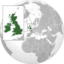
Satellite image of the British Isles, excluding Shetland and the Channel Islands (out of frame)
|
|
 |
|
| Geography | |
| Location | North-western Europe |
| Coordinates | 54°N 4°W / 54°N 4°WCoordinates: 54°N 4°W / 54°N 4°W |
| Adjacent bodies of water | Atlantic Ocean |
| Total islands | 6,000+ |
| Area | 315,159 km2 (121,684 sq mi) |
| Highest elevation | 1,344 m (4,409 ft) |
| Highest point | Ben Nevis |
| Administration | |
| Capital and largest settlement | Saint Peter Port |
| Area covered | 78 km2 (30 sq mi; 0%) |
| Capital and largest settlement | Saint Helier |
| Area covered | 118 km2 (46 sq mi; 0%) |
| Capital and largest city | Dublin |
| Area covered | 70,282 km2 (27,136 sq mi; 22.3%) |
| Capital and largest settlement | Douglas |
| Area covered | 572 km2 (221 sq mi; 0.2%) |
| Capital and largest city | London |
| Area covered | 244,111 km2 (94,252 sq mi; 77.5%) |
| Demographics | |
| Population | 70,763,528 (2017) |
| Pop. density | 216 /km2 (559 /sq mi) |
| Languages | English, Scots, Ulster‑Scots, Welsh, Cornish, Irish, Scottish Gaelic, Manx, French, Jèrriais, Guernésiais, Sercquiais, Auregnais |
| Additional information | |
| Time zone | |
| • Summer (DST) | |
| Drives on the | left |
The British Isles are a group of islands off the north-western coast of continental Europe that consist of the islands of Great Britain, Ireland and over six thousand smaller isles. Situated in the North Atlantic, the islands have a total area of approximately 315,159 km2, and a combined population of just under 70 million. Two sovereign states are located on the islands: Ireland (which covers roughly five-sixths of the island with the same name) and the United Kingdom of Great Britain and Northern Ireland. The British Isles also include three Crown Dependencies: the Isle of Man and, by tradition, the Bailiwick of Jersey and the Bailiwick of Guernsey in the Channel Islands, although the latter are not physically a part of the archipelago.
The oldest rocks in the group are in the north west of Scotland, Ireland and North Wales and are 2,700 million years old. During the Silurian period the north-western regions collided with the south-east, which had been part of a separate continental landmass. The topography of the islands is modest in scale by global standards. Ben Nevis rises to an elevation of only 1,344 metres (4,409 ft), and Lough Neagh, which is notably larger than other lakes on the isles, covers 390 square kilometres (151 sq mi). The climate is temperate marine, with mild winters and warm summers. The North Atlantic Drift brings significant moisture and raises temperatures 11 °C (20 °F) above the global average for the latitude. This led to a landscape which was long dominated by temperate rainforest, although human activity has since cleared the vast majority of forest cover. The region was re-inhabited after the last glacial period of Quaternary glaciation, by 12,000 BC when Great Britain was still a peninsula of the European continent. Ireland, which became an island by 12,000 BC, was not inhabited until after 8000 BC. Great Britain became an island by 5600 BC.
...
Wikipedia
