Geography of South Australia
 |
|
| Continent | Australia |
|---|---|
| Coordinates | 30°S 135°E / 30°S 135°E |
| Area | Ranked 4th among states and territories |
| • Total | 1,043,514 km2 (402,903 sq mi) |
| Coastline | 3,816 km (2,371 mi) |
| Borders | Land borders: Western Australia, Northern Territory, Queensland, New South Wales, Victoria |
| Highest point |
Mount Woodroffe 1,435 m (4,708 ft) |
| Lowest point |
Lake Eyre -15 m (49 ft) |
| Longest river |
Murray River 683 km (424 mi) |
| Largest lake |
Lake Eyre 9690 km² |
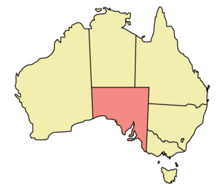
The geography of South Australia incorporates the south central part of the continent of Australia. It is one of the six states of Australia. South Australia is bordered on the west by Western Australia, to the north by the Northern Territory, Queensland to the northeast, and both New South Wales and Victoria to the east. South Australia's south coast is flanked by the Great Australian Bight and the Indian Ocean, although it is referred to locally as the Southern Ocean.
The northern and western parts of the state are extremely arid, in central Australia, dominated by Lake Eyre and Lake Torrens, mostly dry salt lakes. This arid area is sparsely populated, with many large cattle stations, and significant areas protected as national parks, or as Aboriginal lands. The only significant roads through these areas are the Stuart Highway north from Port Augusta to the Northern Territory, the Eyre Highway across the Nullarbor Plain to Western Australia, and the Barrier Highway east to Broken Hill in New South Wales. These highways have corresponding railways: the Trans-Australian Railway going west and east, and the Adelaide–Darwin railway going north.
...
Wikipedia
