Stuart Highway
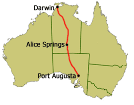
Stuart Highway is one of Australia's major highways. It runs from Darwin, Northern Territory, in the north, via Tennant Creek and Alice Springs, to Port Augusta, South Australia, in the south – a distance of 2,834 km (1,761 mi). Its northern and southern extremities are segments of Australia's Highway 1. The principal north-south route through the central interior of mainland Australia, the highway is often referred to simply as "The Track".
The highway is named after Scottish explorer John McDouall Stuart, who was the first European to cross Australia from south to north. The highway approximates the route Stuart took.
Stuart Highway runs from Darwin, Northern Territory, in the north, via Tennant Creek and Alice Springs, to Port Augusta, South Australia, in the south – a distance of 2,834 km (1,761 mi).
The Royal Flying Doctor Service uses the highway as an emergency landing strip and sections of the highway are signed to that effect. These sections of highway have been specially selected and prepared for the landing of aircraft which only takes place after the piece of road has been closed by the police.
The Northern Territory section of the Stuart Highway starts from the edge of the Darwin Central Business District at Daly Street and continues as a dual-carriageway to the Arnhem Highway in Howard Springs. The highway continues 317 km (197 mi) south passing the Kakadu Highway to the Victoria Highway at Katherine. The route number changes from National Highway 1 to National Highway 87. The highway then continues 673 km (418 mi) south passing the Roper Highway, the Carpentaria Highway and the Buchanan Highway to the Barkly Highway at Tennant Creek. The highway continues 508 km (316 mi) south into Alice Springs passing the Plenty Highway. It passes through the Macdonnell Ranges and finally crosses the South Australia/Northern Territory border south of Kulgera. The highway was only fully sealed in the mid-1980s as part of Australia's bicentenary roadworks programme. There are no police patrolling the majority of this remote highway and until the end of 2006 there was no speed limit outside towns and other built-up areas on the Northern Territory part. The bulk of the Northern Territory's population not living in Darwin lies along its track.
...
Wikipedia

