Lake Eyre
| Kati Thanda–Lake Eyre | |
|---|---|

Composite Landsat 7 satellite image using shortwave infrared, near-infrared, and blue wavelengths
|
|

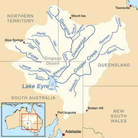
A map of the Lake Eyre basin, with the lake at bottom left
|
|
| Location | Northern South Australia |
| Coordinates | 28°22′S 137°22′E / 28.367°S 137.367°ECoordinates: 28°22′S 137°22′E / 28.367°S 137.367°E |
| Lake type | Endorheic |
| Primary inflows | Warburton River |
| Primary outflows | evaporation |
| Basin countries | Australia |
| Surface area | 9,500 km2 (3,668 sq mi) (max) |
| Average depth | 1.5 m (5 ft) (every 3 years), 4 m (13 ft) (every decade) |
| Surface elevation | −9 m (−30 ft) (shoreline when full); −15 m (−49 ft) (lowest point when empty) |
Lake Eyre (/ˈɛər/ AIR), officially known as Kati Thanda–Lake Eyre, contains the lowest natural point in Australia, at approximately 15 m (49 ft) below sea level (AHD), and, on the rare occasions that it fills, is the largest lake in Australia covering 9,500 km2 (3,668 sq mi). The shallow endorheic lake is the of the vast Lake Eyre basin and is found in Northern South Australia, some 700 km (435 mi) north of Adelaide.
When the lake is full, it has the same salinity level as the sea, but as the lake dries up and the water evaporates, salinity increases.
The lake was named in honour of Edward John Eyre, who was the first European to see it, in 1840. The lake's official name was changed in December 2012 to combine the name "Lake Eyre" with the indigenous name, Kati Thanda.Native title over the lake and surrounding region is held by the Arabana people.
Kati Thanda–Lake Eyre is located in the deserts of central Australia, in northern South Australia. The Lake Eyre Basin is a large endorheic system surrounding the lakebed, the lowest part of which is filled with the characteristic salt pan caused by the seasonal expansion and subsequent evaporation of the trapped waters. Even in the dry season there is usually some water remaining in Kati Thanda–Lake Eyre, normally collecting in over 200 smaller sub-lakes within its margins. The lake was formed by aeolian processes after tectonic upwarping occurred to the south subsequent to the end of the epoch.
...
Wikipedia
