Geography of South Africa
 
|
|
| Continent | Africa |
|---|---|
| Region | Southern Africa |
| Coordinates | 29°00′S 24°00′E / 29.000°S 24.000°E |
| Area | Ranked 25th |
| • Total | 1,220,813 km2 (471,359 sq mi) |
| Coastline | 2,798 km (1,739 mi) |
| Borders |
Total land borders: 4,862 km Botswana 1,840 km, Lesotho 909 km, Mozambique 491 km, Namibia 967 km, Swaziland 430 km, Zimbabwe 225 km |
| Highest point |
Mafadi 3,450 m |
| Lowest point | Sea level 0 m |
| Longest river |
Orange River 2,200 km |
| Largest lake | Lake Chrissie |
| Average temperatures in °C | ||
|---|---|---|
| City | Summer | Winter |
| Cape Town | 20 | 12.6 |
| Durban | 23.6 | 17 |
| Johannesburg | 19.4 | 11.1 |
| Pretoria | 22.4 | 12.9 |
| Source: Lew Leppan: The South African Book of Records. Cape Town, Don Nelson, 1999. | ||
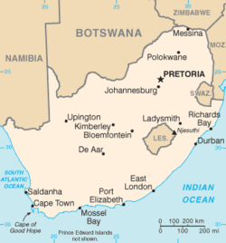
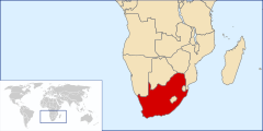
South Africa occupies the southern tip of Africa, its coastline stretching more than 2,500 kilometres (1,600 miles) from the desert border with Namibia on the Atlantic (western) coast southwards around the tip of Africa and then northeast to the border with Mozambique on the Indian Ocean. The low-lying coastal zone is narrow for much of that distance, soon giving way to a mountainous escarpment (Great Escarpment) that separates the coast from the high inland plateau. In some places, notably the province of KwaZulu-Natal in the east, a greater distance separates the coast from the escarpment. Although most of the country is classified as semi-arid, it has considerable variation in climate as well as topography.
South African central plateau contains only two major rivers:
The eastern and southern coastal regions are drained by numerous shorter rivers. There are very few coastal rivers along the arid west coast north of 31°30′S.
In such a dry country, dams and irrigation are extremely important: the largest dam is the Gariep on the Orange River.
Like much of the African continent south of the Sahara, South Africa’s landscape is dominated by a high Central Plateau surrounded by coastal lowlands. This plateau is rimmed by the Great Escarpment which extends northwards to about 10° south of the Equator (i.e. into Angola in the west, and the Muchinga Escarpment in Zambia in the east.)
In South Africa the plateau is at its highest in the east where its edge varies in altitude between 2,000 m and 3,300 m. This edge of the plateau, as the land drops sharply to the coastal plain, forms a very high, steep escarpment known as the Drakensberg Mountains. The southern and western extents of the escarpment are not as high as Drakensberg, but are also known by a wide variety of local names, all termed “mountains” (or “berge” in Afrikaans), in spite of being parts of an escarpment whose top is the central plateau. From the coastal plain the escarpment does, however, look like a range of mountains, hence the names.
...
Wikipedia
