Geography of Qatar
 |
|
| Continent | Asia |
|---|---|
| Coordinates | 25°18′N 51°09′E / 25.30°N 51.15°E |
| Area | Ranked 164th |
| • Total | 11,571 km2 (4,468 sq mi) |
| • Land | 100% |
| • Water | 0% |
| Coastline | 563 km (350 mi) |
| Borders | Saudi Arabia: 60 km (37 mi) |
| Highest point |
Qurayn Abu al Bawl, 103 m (338 ft) |
| Lowest point |
Persian Gulf, 0 m (0 ft) |
| Climate | arid; mild, pleasant winters; very hot, humid summers |
| Terrain | mostly flat and barren desert covered with loose sand and gravel |
| Natural Resources | petroleum, natural gas, fish |
| Natural Hazards | haze, dust storms, sandstorms common |
| Environmental Issues | limited natural freshwater resources are increasing dependence on large-scale desalination facilities |
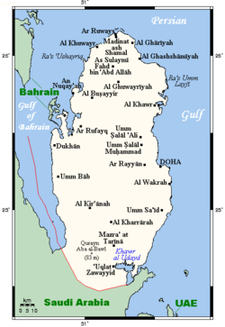
Qatar is a peninsula in the east of Arabia, bordering the Persian Gulf and Saudi Arabia, in a strategic location near major petroleum deposits. Qatar occupies 11,437 km2 (4,416 sq mi) on a peninsula that extends approximately to 160 km (99 mi) north into the Persian Gulf from the Arabian Peninsula.
Varying in width between 55 and 90 km (34 and 56 mi), the land is mainly flat (the highest point is 103 m (338 ft)) and rocky. Notable features include coastal salt pans, elevated limestone formations (the Dukhan anticline) along the west coast under which lies the Dukhan oil field, and massive sand dunes surrounding Khawr al Udayd, an inlet of the Persian Gulf in the southeast known to local English speakers as the Inland Sea.
The peninsula of Qatar is low-lying. Its shape the surface expression of the Qatar Arch, one of the largest structural characteristics of the Arabian Plate. It is enveloped by loose sand and pebbles broken off the outcropping limestone. Smooth plains are found in the east, where the surface is covered by fine-grained dust. The south and south-west portion of the peninsula mainly comprises sand dunes and salt flats.
The coastline is emergent and gently slopes toward the sea. Many flat, low-lying offshore islands are located near the coast and are accompanied by coral reefs. As a result of salt water coming into contact with the low-lying land, many salt pans have formed near the coast.
The long summer (May through September) is characterized by intense heat and alternating dryness and humidity, with temperatures reaching 50 °C (122 °F). Temperatures are moderate from November to April, ranging from as high as 39 °C (102 °F) in April to as low as 7 °C (45 °F) in January. Rainfall is negligible, averaging 100 mm (3.9 in) per year, confined to the winter months, and falling in brief, sometimes heavy storms that often flood the small ravines and the usually dry wadis.
Sudden, violent dust storms occasionally descend on the peninsula, blotting out the sun, causing wind damage, and temporarily disrupting transport and other services.
The scarcity of rainfall and the limited underground water, most of which has such a high mineral content that it is unsuitable for drinking or irrigation, restricted the population and the extent of agricultural and industrial development the country could support until desalination projects began. Although water continues to be provided from underground sources, most is obtained by desalination of seawater.
...
Wikipedia
