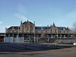
Geldermalsen
| Geldermalsen | |||
|---|---|---|---|
| Municipality | |||

|
|||
|
|||
 Location in Gelderland |
|||
| Coordinates: 51°53′N 5°17′E / 51.883°N 5.283°ECoordinates: 51°53′N 5°17′E / 51.883°N 5.283°E | |||
| Country | Netherlands | ||
| Province | Gelderland | ||
| Government | |||
| • Body | Municipal council | ||
| • Mayor | Miranda de Vries (PvdA) | ||
| Area | |||
| • Total | 101.73 km2 (39.28 sq mi) | ||
| • Land | 99.98 km2 (38.60 sq mi) | ||
| • Water | 1.75 km2 (0.68 sq mi) | ||
| Elevation | 4 m (13 ft) | ||
| Population (May 2014) | |||
| • Total | 26,334 | ||
| • Density | 263/km2 (680/sq mi) | ||
| Time zone | CET (UTC+1) | ||
| • Summer (DST) | CEST (UTC+2) | ||
| Postcode | 4150–4158, 4190–4197 | ||
| Area code | 0345 | ||
| Website | www |
||
Geldermalsen (![]() pronunciation ) is a municipality and a town in the western Netherlands. The municipality of Geldermalsen was formed on the 1 January 1978 when the former municipalities of Beesd, Buurmalsen, Deil and Geldermalsen were joined. The new municipality with an area of 101.73 km2 (39.28 sq mi) is one of the largest municipalities in the Western Betuwe. The municipality had a population of 26,334 in 2014. They all live in the eleven villages that form Geldermalsen.
pronunciation ) is a municipality and a town in the western Netherlands. The municipality of Geldermalsen was formed on the 1 January 1978 when the former municipalities of Beesd, Buurmalsen, Deil and Geldermalsen were joined. The new municipality with an area of 101.73 km2 (39.28 sq mi) is one of the largest municipalities in the Western Betuwe. The municipality had a population of 26,334 in 2014. They all live in the eleven villages that form Geldermalsen.
The river Linge flows through Geldermalsen. The town of Geldermalsen itself had a population of 10,637 in 2006.
Dutch Topographic map of the municipality of Geldermalsen, June 2015
Demographics of Geldermalsen, 2010:
The road bridge between Buurmalsen and Geldermalsen
Linge river
Windmill in Geldermalsen
Tower of the Reformed Church in the center of Geldermalsen
Choir of the Reformed Church
The villa was built in 1929 by architect A. H. Wegerif
...
Wikipedia


