Geldermalsen (town)
| Geldermalsen | |||
|---|---|---|---|
| Municipality | |||

|
|||
|
|||
 Location in Gelderland |
|||
| Coordinates: 51°53′N 5°17′E / 51.883°N 5.283°ECoordinates: 51°53′N 5°17′E / 51.883°N 5.283°E | |||
| Country | Netherlands | ||
| Province | Gelderland | ||
| Government | |||
| • Body | Municipal council | ||
| • Mayor | Miranda de Vries (PvdA) | ||
| Area | |||
| • Total | 101.73 km2 (39.28 sq mi) | ||
| • Land | 99.98 km2 (38.60 sq mi) | ||
| • Water | 1.75 km2 (0.68 sq mi) | ||
| Elevation | 4 m (13 ft) | ||
| Population (August 2017) | |||
| • Total | 26,767 | ||
| • Density | 268/km2 (690/sq mi) | ||
| Time zone | CET (UTC+1) | ||
| • Summer (DST) | CEST (UTC+2) | ||
| Postcode | 4150–4158, 4190–4197 | ||
| Area code | 0345 | ||
| Website | www |
||
Geldermalsen (![]() pronunciation ) is a municipality and a town in the province of Gelderland in the Netherlands.
pronunciation ) is a municipality and a town in the province of Gelderland in the Netherlands.
The municipality of Geldermalsen was formed on January 1st, 1978, when the former municipalities of Beesd, Buurmalsen, Deil and Geldermalsen were combined. The municipality has an area of 101.73 km2 (39.28 sq mi) and is one of the largest municipalities in the Betuwe. The municipality had a population of 26,767 in 2017.
The river Linge flows through the municipality and town of Geldermalsen.
The town centre of Geldermalsen contains a two-aisled Gothic church dating from the 15th century, with a Romanesque tower dating from the 13th century. The west wall of the nave contains tuff parts of a 12th century Romanesque predecessor.
The town contains two windmills: De Watermolen, which was built in 1772, and De Bouwing, which was built in 1848.
Geldermalsen had a population of 10,586 on January 1st, 2015.
Demographics of the municipality of Geldermalsen in 2010:
Reformed church in the center of Geldermalsen
Reformed church in the center of Geldermalsen
Farm Groot Westerhout in Geldermalsen (1771)
Windmill De Watermolen in Geldermalsen (1772)
Windmill De Bouwing in Geldermalsen (1848)
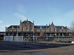
Geldermalsen railway station (1884)
Villa Bottesteyn in Geldermalsen, built by architect E.G. Wentink jr. in 1903
...
Wikipedia

