Garona
| Garonne | |
|---|---|

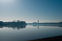
The Garonne at Bordeaux
|
|

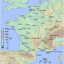
Map of the Garonne
|
|
| Native name | La Garonne |
| Country | France, Spain |
| Physical characteristics | |
| Main source |
Pyrenees 2,600 m (8,500 ft) 42°36′26″N 0°57′56″E / 42.607295°N 0.965424°E |
| River mouth |
Gironde estuary, Atlantic Ocean 45°2′29″N 0°36′24″W / 45.04139°N 0.60667°WCoordinates: 45°2′29″N 0°36′24″W / 45.04139°N 0.60667°W |
| Length | 602 km (374 mi) |
| Discharge |
|
| Basin features | |
| Basin size | Including Dordogne: 84,811 km2 (32,746 sq mi) |
The Garonne (French: Garonne, IPA: [ɡaʁɔn]; in Occitan, Catalan, and Spanish: Garona; Latin: Garumna or Garunna) is a river in southwest France and northern Spain, with a length of 602 kilometres (374 mi). It flows into the Atlantic Ocean at Bordeaux.
The name derives from Garumna, a Latinized version of the Aquitanian name meaning "stony river".
The Garonne's headwaters are to be found in the Aran Valley in the Spanish Pyrenees, though three different locations have been proposed as the true source: the Uelh deth Garona at Plan de Beret (42°42′34″N 0°56′43″E / 42.709494°N 0.945398°E), the Ratera-Saboredo cirque 42°36′26″N 0°57′56″E / 42.607295°N 0.965424°E), or the slopes of Pic Aneto (Salterillo-Barrancs ravine 42°38′59″N 0°40′06″E / 42.6498°N 0.6683°E according to the season).
...
Wikipedia
