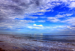
Galveston Island State Park
| Galveston Island State Park | |
| Park | |
|
on the Gulf of Mexico. |
|
| Country | United States |
|---|---|
| State | Texas |
| Region | Galveston County |
| District | Galveston Island |
| Municipality | Galveston, Jamaica Beach |
| Biome | Coastal dunes, brackish wetlands |
| Geology | Barrier island |
| For public | Texas state park |
| Official website: [1] | |
Galveston Island State Park is a Texas state park located on western Galveston Island in Galveston County, on the western Gulf Coast in Texas.
The park protects 2,013.1-acre (814.7 ha) of dunes, estuaries, wetlands, brackish ponds, and beaches. It was established in 1975. It is adjacent to the city of Galveston.
Habitats include surf, beach, dunes, coastal prairie, fresh-water ponds, wetlands, bayous and bay shoreline. It has numerous trails for scenery and wildlife viewing. There is a public campground in the park.
Galveston Island is a barrier island between Galveston Bay and the Gulf of Mexico. The island began to form around 5,000 years ago. It took another 3,000 years for the core to become high enough to withstand typical storm surges. American Indians began to visit Galveston Island around 2,000 years ago.
In the 16th century, Spanish exploration initiated European interaction with the indigenous Akokisa and Karankawa peoples. It is believed that Cabeza de Vaca and his crew were shipwrecked here in 1520 and eventually made their way from the island to colonial New Spain (México).
The LaFitte brothers, fleeing the prosecution of pirates in the Caribbean, established a "government" here in 1817, with visions of creating a "Manhattan on the Gulf." Commerce did thrive here, but major storms in 1867, 1871, 1875, and 1886 greatly slowed progress. The Galveston Hurricane of 1900 devastated the island, killing 5000 to 10,000 people, and prompted the construction of the seawall which protects the northern half of the island.
...
Wikipedia

