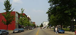
Gallipolis
| Gallipolis, Ohio | |
|---|---|
| village | |

State Route 7 downtown
|
|
| Nickname(s): City of the Gauls | |
 Location of Gallipolis, Ohio |
|
 Location of Gallipolis in Gallia County |
|
| Coordinates: 38°48′55″N 82°11′51″W / 38.81528°N 82.19750°WCoordinates: 38°48′55″N 82°11′51″W / 38.81528°N 82.19750°W | |
| Country | United States |
| State | Ohio |
| County | Gallia |
| Township | Gallipolis |
| Area | |
| • Total | 3.83 sq mi (9.92 km2) |
| • Land | 3.60 sq mi (9.32 km2) |
| • Water | 0.23 sq mi (0.60 km2) |
| Elevation | 574 ft (175 m) |
| Population (2010) | |
| • Total | 3,641 |
| • Estimate (2014) | 3,607 |
| • Density | 1,011.4/sq mi (390.5/km2) |
| Time zone | Eastern (EST) (UTC-5) |
| • Summer (DST) | EDT (UTC-4) |
| ZIP code | 45631 |
| Area code(s) | 740 |
| FIPS code | 39-29204 |
| GNIS feature ID | 1077526 |
| Website | Village of Gallipolis website |
Gallipolis (/ˌɡæləpəˈlis/ GAL-ə-pə-LEES) is a chartered village in the U.S. state of Ohio and the county seat of Gallia County. The municipality is located in Southeast Ohio on the Ohio River. The population was 3,641 at the 2010 census. When the population dropped below 5,000, Gallipolis became a village, but continues to operate under its existing city charter.
Gallipolis is the second-largest community in the Point Pleasant Micropolitan Statistical Area, which includes all of Gallia County, Ohio and Mason County, West Virginia.
Gallipolis was first settled in 1790 by "The French 500," a group of French aristocrats and merchants who were fleeing the French Revolution. They were led by Count Jean-Joseph de Barth, an Alsatian member of the French National Assembly.
The name Gallipolis, a construct of the Greek or Latin prefix "Galli-" and the Greek suffix "-polis", means "city of the French", though it is often incorrectly cited that city derives from French, who refer to ancient France as Gaul. A post office called Gallipolis has been in operation since 1794.
...
Wikipedia
