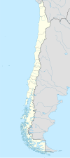
Futaleufú, Chile
| Futaleufú | |||||
|---|---|---|---|---|---|
| Town and Commune | |||||
|
|||||
| Nickname(s): "Futa" | |||||
| Coordinates: 43°11′0″S 71°52′0″W / 43.18333°S 71.86667°WCoordinates: 43°11′0″S 71°52′0″W / 43.18333°S 71.86667°W | |||||
| Country | Chile | ||||
| Region | Los Lagos | ||||
| Province | Palena | ||||
| Government | |||||
| • Type | Municipality | ||||
| • Alcalde | Arturo Carvallo Pardo (DC) | ||||
| Area | |||||
| • Total | 1,280.0 km2 (494.2 sq mi) | ||||
| Elevation | 353 m (1,158 ft) | ||||
| Population (2012 Census) | |||||
| • Total | 2,297 | ||||
| • Density | 1.8/km2 (4.6/sq mi) | ||||
| • Urban | 1,153 | ||||
| • Rural | 673 | ||||
| Sex | |||||
| • Men | 954 | ||||
| • Women | 872 | ||||
| Area code(s) | 56 + 65 | ||||
| Climate | Cfb | ||||
| Website | Municipality of Futaleufú | ||||
Futaleufú is a Chilean town and commune located in Northern Patagonia, specifically in Palena Province, Los Lagos Region. Futaleufu is a frontier town with a small but growing tourism industry based on adventure tourism—most specifically whitewater rafting—but also fishing, mountain biking, trekking, and canyoning. Located 7 miles from the Argentinian border, Futaleufu is most easily accessed from airports in Esquel and Bariloche, Argentina. The town is named after the crystal blue Futaleufú River widely considered to be one of the three greatest whitewater rafting rivers in the world. The name Futaleufu derives from a Mapudungun word meaning "Big River". Following the eruption of Chaitén Volcano and the subsequent destruction of Chaitén, Futaleufú has been the administrative capital of Palena Province since March 2009. The town has a population of about 2,000. The main income for the community is fly fishing and outdoor sports, particularly white water rafting, together with forestry and cattle farming. A gravel road links the town to Trevelin in Argentina and to the Carretera Austral.
Futaleufú has an oceanic climate (Köppen climate classification Cfb) with some drying trend in summer. Winters are cool and wet but mild with a July average of 3.6 °C (38.5 °F). During this time of the year, precipitation is very high, averaging around 253 to 301 millimetres (10 to 12 in) from June to August and humidity is high, averaging around 77–86%. Few days are dry in winter, since there are 18–19 days with measurable precipitation from June to August. Snowfalls occur in most years though prolonged snowfall events are uncommon. Summers are drier and mild with a January average of 16.8 °C (62.2 °F) and during this time, precipitation is lower, averaging 81.1 millimetres (3 in) in February, the driest month. However, precipitation during the summer months are highly variable; in some years, many days can go without a day of precipitation such as the case in 1987 when only 9.9 millimetres (0 in) of precipitation was recorded in January while in other years, some monthly precipitation can exceed 300 millimetres (12 in) such as in January 1974. Temperatures can occasionally exceed 20 °C (68 °F) anytime from September to May. The average annual precipitation is 2,081.2 millimetres (82 in) and there are 169 days with measureable precipitation although this can vary widely from year to year, ranging from a high of 3,536.8 millimetres (139 in) in 1971 to a low of only 1,159.3 millimetres (46 in) in 1998. The record high was 37.0 °C (98.6 °F) on December 1956 and the record low was −11.2 °C (11.8 °F) in July 2007.
...
Wikipedia


