Fort Amherst (Newfoundland and Labrador)
| Fort Amherst | |
|---|---|
| Neighbourhood | |

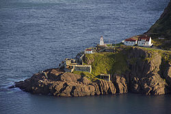
Fort Amherst from Signal Hill
|
|
| Country |
|
| Province |
|
| City | St. John's |
| Ward | 2 |
| Government | |
| • Administrative body | St. John's City Council |
| • Councilor |
Frank Galgay |
| Official name | Fort Amherst National Historic Site of Canada |
| Designated | 1951 |

Fort Amherst Lighthouse
|
|
|
Newfoundland
|
|
| Location | Fort Amherst St. John's Newfoundland Canada |
|---|---|
| Coordinates | 47°33′48.68″N 52°40′49.52″W / 47.5635222°N 52.6804222°W |
| Year first constructed | 1813 (first) 1852 (second) |
| Year first lit | 1951 (current) |
| Construction | stone tower (first) wooden tower (current) |
| Tower shape | square frustun tower with balcony and lantern |
| Markings / pattern | white tower, red lantern roof |
| Height | 8 metres (26 ft) |
| Focal height | 40 metres (130 ft) |
| Range | 17 nautical miles (31 km; 20 mi) |
| Characteristic | Fl W 15s. |
| Admiralty number | H0458 |
| CHS number | CCG 506 |
| NGA number | 1848 |
| ARLHS number | CAN-683 |
| Managing agent | Fort Amherst Museum and Tea Room |
| Heritage |
national historic site of Canada |
Frank Galgay
Fort Amherst is a neighbourhood in St. John's, Newfoundland and Labrador. It is located at 47°33′48.96″N 52°40′49.60″W / 47.5636000°N 52.6804444°WCoordinates: 47°33′48.96″N 52°40′49.60″W / 47.5636000°N 52.6804444°W, on the southern side of the Narrows, the entrance to St. John's harbour. Apart from some family dwellings, Fort Amherst consists of a man-made harbour, a lighthouse and the remains of gun emplacements and pillboxes built during World War II to defend against German U-boats. Two QF 4.7-inch B Mark IV* guns remain in place, and can still be seen on their mountings.
The original fortifications at Fort Amherst, built in the 1770s, are no longer visible. The fortifications were named for William Amherst, who successfully recaptured St. John's from French forces in 1762. The site was designated a National Historic Site of Canada in 1951.
...
Wikipedia

