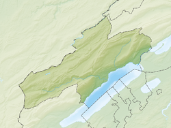
Fontaines, Switzerland
| Fontaines | ||
|---|---|---|
| Former municipality of Switzerland | ||
|
||
| Coordinates: 47°2.5′N 6°54′E / 47.0417°N 6.900°ECoordinates: 47°2.5′N 6°54′E / 47.0417°N 6.900°E | ||
| Country | Switzerland | |
| Canton | Neuchâtel | |
| District | Val-de-Ruz | |
| Area | ||
| • Total | 10.14 km2 (3.92 sq mi) | |
| Elevation | 768 m (2,520 ft) | |
| Population (December 2011) | ||
| • Total | 1,132 | |
| • Density | 110/km2 (290/sq mi) | |
| Postal code | 2046 | |
| SFOS number | 6479 | |
| Surrounded by | Boudevilliers, Cernier, Engollon, Fenin-Vilars-Saules, Fontainemelon, La Chaux-de-Fonds, La Sagne, Les Hauts-Geneveys, Renan (BE) | |
| Website |
www SFSO statistics |
|
Fontaines is a former municipality in the district of Val-de-Ruz in the canton of Neuchâtel in Switzerland.
The municipalities of Boudevilliers, Cernier, Chézard-Saint-Martin, Coffrane, Dombresson, Engollon, Fenin-Vilars-Saules, Fontainemelon, Fontaines, Les Geneveys-sur-Coffrane, Les Hauts-Geneveys, Montmollin, Le Pâquier, Savagnier and Villiers merged on 1 January 2013 into the new municipality of Val-de-Ruz.
Fontaines is first mentioned in 1228 as Fontanes.
Fontaines had an area, as of 2009[update], of 10.1 square kilometers (3.9 sq mi). Of this area, 6.39 km2 (2.47 sq mi) or 63.0% is used for agricultural purposes, while 2.89 km2 (1.12 sq mi) or 28.5% is forested. Of the rest of the land, 0.76 km2 (0.29 sq mi) or 7.5% is settled (buildings or roads), 0.04 km2 (9.9 acres) or 0.4% is either rivers or lakes and 0.02 km2 (4.9 acres) or 0.2% is unproductive land.
Of the built up area, housing and buildings made up 2.3% and transportation infrastructure made up 3.6%. Power and water infrastructure as well as other special developed areas made up 1.2% of the area Out of the forested land, 23.5% of the total land area is heavily forested and 5.0% is covered with orchards or small clusters of trees. Of the agricultural land, 29.9% is used for growing crops and 5.4% is pastures and 27.6% is used for alpine pastures. All the water in the municipality is flowing water.
...
Wikipedia


